


Sudden Atmospheric Shift
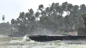
Mumbai and its surrounding areas, including Thane and Navi Mumbai, were unexpectedly swept by intense, gusty winds on Thursday afternoon. This dramatic
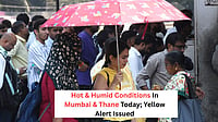
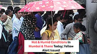
change in weather arrived as a surprise, particularly after the day had been characterized by uncomfortably high temperatures, with several locations recording a maximum of 37 degrees Celsius. Areas like Ram Mandir in Mumbai registered this peak, with Vikhroli and Bandra also experiencing temperatures around 35 degrees. Similarly, Thane recorded a high of 37 degrees. These elevated temperatures were occurring under a yellow alert for hot and humid conditions that was in effect for the entire Konkan region and was expected to persist until Saturday, painting a picture of a typically sweltering late afternoon.
Weather Warnings Issued
Following the onset of these stormy conditions around 4 pm, the India Meteorological Department (IMD) quickly issued a nowcast warning. This alert specifically targeted Thane, Navi Mumbai, and extended to districts such as Palghar, Raigad, and Ratnagiri. The warning indicated a possibility of gusty winds reaching speeds of 30-40 kmph, accompanied by the potential for thunderstorms, lightning, and rain. This warning was particularly noteworthy because the stormy activity itself was occurring without any prior explicit warnings for thunderstorms being in place. The forecast for the Konkan region had initially only predicted hot and humid weather, making the sudden gusty winds and the subsequent nowcast warning a significant deviation from expectations.
Fleeting Storm, No Rain
Despite the issued warnings and the visible storm-like activity, the intense weather phenomenon proved to be remarkably short-lived. Crucially, actual rain, thunder, and lightning eluded Mumbai and its neighboring areas. By 5:30 pm on Thursday, IMD observatories across the city and its adjacent pockets registered 'NIL' rainfall, a stark contrast to the potential showers indicated in the nowcast warning. This meant that while dust was swirled around by the strong winds, the much-anticipated precipitation did not materialize, leaving the region dry.
Cloud Dynamics Explained
According to Bikram Singh, the director of the IMD, the unusual gusty winds experienced in Mumbai were likely a direct consequence of thundercloud development in the vicinity. He explained that a combination of an active cyclonic circulation, coupled with ample moisture and heat present in the atmosphere, creates the ideal conditions for cloud formation. Even though these thunderclouds were situated a few kilometers away from the city, their proximity was sufficient to generate powerful gusty winds that swept through the nearby regions. This atmospheric phenomenon resulted in the eastern suburbs of Mumbai experiencing the observed stormy activity, despite the clouds not directly overhead.
Broader Regional Impact
While the immediate focus was on Mumbai and its suburbs, the IMD also provided updates for other regions. Following the earlier nowcast warning, an updated forecast bulletin was issued at 5:05 pm for Thane and Palghar, placing these districts under a yellow alert. This alert indicated a likelihood of thunderstorms and light rain persisting until Friday morning. It's also worth noting that while the Konkan region had no specific alerts issued at the time, several other districts across Maharashtra, including those in the Vidarbha and Marathwada regions, were already under yellow warnings for potential thunderstorm activity, indicating a broader pattern of unsettled weather across parts of the state.