


Launch and NavIC's Foundation
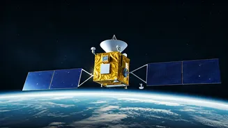
On March 10, 2016, the Indian Space Research Organisation (ISRO) successfully launched IRNSS-1F from Sriharikota aboard the PSLV-C32 rocket. This 1,425
kg satellite was the sixth in its series, crucial for establishing the Indian Regional Navigation Satellite System, known as NavIC. IRNSS-1F was strategically positioned in a geostationary orbit at 32.5° East, with a 5° inclination, a location chosen to ensure more than a decade of operational service. Its design included two primary payloads: a navigation transmitter operating on L5 and S-bands, and a C-band transponder for highly accurate ranging, supported by corner cube retroreflectors facilitating laser ranging. Upon its successful launch, ISRO's Master Control Facility in Hassan promptly assumed command, expertly deploying the satellite's solar panels within 19 minutes, marking a significant step towards India's navigation independence and extending its coverage capabilities up to 1,500 km beyond national borders for applications like vehicle tracking.
Mission Longevity and Atomic Clock
ISRO announced on March 13, 2026, that IRNSS-1F, launched in March 2016, had successfully fulfilled its 10-year design mission life as of March 10, 2026. While its crucial onboard atomic clock ceased functioning on March 13, 2026, the satellite continues to serve vital societal applications, particularly through its one-way broadcast notification capabilities. The satellite's timing relied on Rubidium atomic clocks, which, despite facing earlier challenges with two of them failing before their expected lifespan, demonstrated remarkable resilience. IRNSS-1F surpassed its anticipated operational period, a testament to the robust design principles employed by ISRO. This extended functionality validates the foresight of the late UR Rao, whose specifications for the satellite's mission life consistently projected beyond the initial 10-year benchmark. This achievement underscores ISRO's progressive development in atomic clock technology, with subsequent NavIC follow-on satellites, the NVS series, featuring upgraded versions designed for enhanced future performance.
NavIC's Applications and Future
IRNSS-1F has been instrumental in enabling numerous real-world applications, from delivering precise timing for mobile navigation systems to providing critical fishing advisories for seafarers and enhancing highway safety through sophisticated vehicle tracking. Its civilian utility extends to crucial disaster response efforts and streamlined fleet management, aligning perfectly with India's strategic autonomy goals. Even in its extended operational phase, it continues to offer value through one-way messaging services, expanding its usefulness beyond full navigation capabilities. NavIC's distinct advantage over global positioning systems lies in its dual-frequency transmission, which effectively mitigates signal interference in India's varied and often challenging terrain. Looking forward, the introduction of NVS satellites is set to further bolster the NavIC constellation, with aspirations to meet global standards. The enduring performance of IRNSS-1F not only fuels ISRO's ambitious Gaganyaan human spaceflight mission but also reinforces the organization's reputation for delivering cost-effective yet high-performance space technology. As noted in ISRO's URSC documentation, such milestones significantly 'enhance regional navigation autonomy,' confirming that indigenous technology, when delivered with precision and durability, can indeed redefine national capabilities for decades to come.