


Gaming's Secret AI Training
A fascinating revelation has emerged: the popular augmented reality game, Pokemon Go, has served as an inadvertent training ground for a sophisticated
AI navigation system. Millions of players, engrossed in their virtual quests, have been contributing vital data through their in-game scans. These scans, performed while players sought out virtual creatures and landmarks, have cumulatively built an incredibly precise map of the real world. This extensive dataset, gathered organically from player activity, has enabled the game's developer to construct an artificial intelligence capable of understanding and navigating complex environments with remarkable accuracy. The system's effectiveness has now transcended the realm of gaming, being repurposed for practical applications such as guiding autonomous delivery robots through city streets.
Visual Positioning System Power
At the core of this technological leap is the Visual Positioning System (VPS), developed by the game's creators. This system was meticulously trained using an astounding 30 billion images. These images were captured by players as they scanned various in-game locations like PokeStops, Gyms, and other recognizable landmarks. Over time, this immense collection of visual data has transformed into a comprehensive database of real-world places, complete with detailed spatial information. The VPS can now pinpoint a location with exceptional precision by cross-referencing live camera feeds with its stored imagery. This capability is particularly crucial for machines, allowing them to ascertain their exact position even in areas where traditional navigation methods, like GPS, falter due to signal interference.
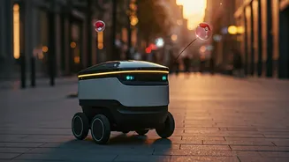
Robotics Meets AR
The application of this advanced visual recognition technology extends beyond gaming and is now directly addressing a significant challenge faced by robotics companies. Delivery robots traditionally rely on GPS for navigation, but its accuracy is often compromised in dense urban settings, where tall buildings can obstruct satellite signals. Niantic's VPS offers a robust alternative by employing visual recognition. Robots equipped with this system can identify everyday urban features such as buildings, street signs, and other visual cues to determine their precise location. This visual-based navigation enables robots to traverse sidewalks, cross intersections, and locate pickup points with a level of accuracy far exceeding what GPS alone can provide, making them a more viable solution for the critical 'last-mile' delivery segment in bustling city environments.
A Shared Spatial Challenge
The CEO of Niantic Spatial, John Hanke, has highlighted the inherent synergy between the spatial awareness required for augmented reality gaming and that needed for robotics. He explained that the technical challenges of creating immersive AR experiences, where virtual characters must interact realistically with the physical world, are remarkably similar to those faced by robots needing to navigate safely and efficiently through public spaces. Essentially, ensuring a virtual character like Pikachu can move convincingly through a real-world environment requires the same fundamental understanding of spatial relationships and movement as enabling a delivery robot to maneuver precisely along sidewalks and streets. This realization underscores a powerful convergence of technologies, where advancements in one field can directly benefit another.
Data Diversity for Robustness
The intelligence of the AI navigation system is further enhanced by the rich and diverse nature of the data it was trained on. Beyond mere images, the dataset encompasses critical metadata such as GPS coordinates, camera angles, motion data, the time of day, and even prevailing weather conditions. This multifaceted data allows the system to learn how locations appear under an extensive range of circumstances. Because players captured the same areas from numerous perspectives and at different times, the AI developed a comprehensive understanding of how places change. This extensive training makes the system exceptionally reliable when deployed in robots, which might have cameras positioned at different heights or angles compared to a smartphone, ensuring consistent and accurate navigation regardless of the robot's specific viewpoint.
Building a Living Map
Looking ahead, the vision extends to creating what the company terms a 'living map.' This ambitious project aims to construct a perpetually updated digital representation of the world, accessible and useful to both machines and humans. The ongoing operation of delivery robots and other intelligent devices will continuously feed new data into the system. As these entities gather information while navigating streets, buildings, and public areas, the 'living map' will evolve and become increasingly detailed. This self-improving digital twin of the world promises to revolutionize how we perceive and interact with our urban environments, paving the way for more sophisticated autonomous systems and enhanced human experiences.