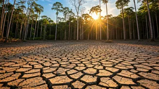

Heat and Deforestation
Scientists at the University of Leeds have created a new interactive map that shows a concerning reality: deforestation leads to significant temperature
increases in tropical zones. The map illustrates how removing forests directly contributes to local warming, with potential rises of up to 5°C. This localized heating isn't just a minor inconvenience; it has profound repercussions for human health, access to clean water, agricultural practices, and the overall ability of communities to withstand the effects of climate change, particularly those already facing vulnerabilities across the tropics. The initiative provides a clear visual of the environmental consequences caused by deforestation, helping policymakers and communities to understand and address the problem effectively.
Regional Temperature Spikes
The interactive map offers detailed insights into the specific temperature increases experienced in various regions due to deforestation. For instance, the map pinpoints that deforestation in Rondônia, a state in the southern Amazon of Brazil, could lead to local warming of 2.1°C. Furthermore, certain areas in Southeast Asia and Africa are predicted to experience even more substantial warming, exceeding 3°C, as a result of deforestation. In the Katavi Region of Tanzania, the impact is particularly stark, where deforestation could cause a temperature increase of over 5°C. These regional examples highlight the localized nature of the problem, allowing for targeted strategies in regions facing the most severe impacts, thereby emphasizing the urgent need for focused conservation efforts.
Supporting Forest Protection
The research's findings provide a strong foundation for promoting and prioritizing forest protection and curbing deforestation. By highlighting the direct link between forest loss and temperature increases, the study equips policymakers and stakeholders with critical information. Understanding how forests naturally regulate temperatures at a local scale is essential for informed decision-making. Initiatives such as the Brazil-led Tropical Forests Forever Facility, with support from the UK, aim to safeguard millions of people by mitigating the impacts of extreme heat and promoting climate resilience. The facility, which is set to launch at COP30, symbolizes a global commitment to address the problem.
Map's Unique Significance
This interactive map represents a pioneering tool that empowers stakeholders from tropical nations to comprehend the full scope of deforestation's impact on their local climates. It offers an unprecedented level of detail, showcasing the precise relationship between forest loss and temperature variations in specific regions. By making this information readily accessible, the map facilitates a more profound understanding of the issue, enabling communities to develop targeted and effective adaptation strategies. This is especially vital for vulnerable populations, helping them to develop resilience to the effects of climate change. The map provides a critical resource for conservation efforts.
Ecosystem Services Revealed
The interactive map also underscores the invaluable role of forests in providing crucial ecosystem services to society. Forests play a vital part in maintaining stable local climates. Protecting existing forests and actively planting new trees emerges as an effective strategy for localized climate adaptation. By showcasing these ecological benefits, the research emphasizes the holistic value of forests, extending beyond their function in carbon sequestration and biodiversity conservation. This underscores the need for a comprehensive approach that considers forests' role in regulating temperatures and supporting human well-being. The findings suggest strategies for climate action.