
A record snow drought with unprecedented heat is hitting most of the American West, depleting future water supplies, making it more vulnerable to wildfires and hurting winter tourism and recreation.
Scientists
say snow cover and snow depth are both at the lowest levels they’ve seen in decades, while at least 67 Western weather stations have measured their warmest December through early February on record. Normal snow cover this time of year should be about 460,000 square miles — about the size of California, Utah, Idaho and Montana — but this year it's only California-sized, about 155,000 square miles, according to the National Snow and Ice Data Center.
“I have not seen a winter like this before,” said center director Mark Serreze, who has been in Colorado almost 40 years. "This pattern that we’re in is so darned persistent.”
The snowpack — measured by how much water is trapped inside — in Oregon is not only record low, but 30% lower than the previous record, said Jason Gerlich, regional drought early warning system coordinator for the National Oceanic and Atmospheric Administration.
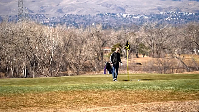
Much of the U.S. east of the Rockies is snowbound and enduring more than two weeks of bone-chilling abnormal cold, but in West Jordan, Utah, a suburb of Salt Lake City, Trevor Stephens went to the store last week in gym shorts and a T-shirt.
“Right now there’s no snow on the ground,” he said in a video interview, looking out his window and lamenting the lack of snowboarding opportunities. "I’d definitely rather have icy roads and snow than whatever is going on out here right now.”
Ski resorts had already been struggling through a difficult season, but the lack of snow has been persistent enough that concerns are growing about wider effects.
Oregon, Colorado and Utah have reported their lowest statewide snowpack since the early 1980s, as far back as records go.
A dry January has meant most states have received half their average precipitation or even less. Along with sunny days and higher-than-average temperatures, that's meant little snow buildup in a month that historically gets a lot of snow accumulation across much of the Pacific Northwest and Northern Rockies. Because of heavy rains in December, California is in better shape than the other states, scientists said.
As of Monday, it had been 327 days since Salt Lake City International Airport got 1 inch of snow, making it the longest stretch since 1890-91, according to the National Weather Service.
The meager snow in Colorado and Utah has put the Upper Colorado River Basin at the heart of the snow drought, said Gerlich.
A robust mountain snowpack that slowly melts as winter warms to spring provides a steady flow of water into creeks and rivers. That helps ensure there’s enough water later in the year for agriculture, cities, hydropower electric systems and more.
But lack of snow or a too-fast melt means less water will replenish rivers like the Colorado later in the season.
“This is a pretty big problem for the Colorado basin,” said Daniel Swain of the University of California’s Water Resources Institute.
Experts said the snow drought could also kick-start an early wildfire season. Snow disappearing earlier than average leaves the ground exposed to warmer weather in the spring and summer that dries soils and vegetation quicker, said Daniel McEvoy, researcher with the Western Regional Climate Center.
While it's been dry, the record-low snowpack is mostly due to how warm the West has been, which is connected to climate change from the burning of coal, oil and natural gas, several scientists said. Since Dec. 1, there have been more than 8,500 daily high temperature records broken or tied in the West, according to NOAA data.
Much of the precipitation that would normally fall as snow and stay in the mountains for months is instead falling as rain, which runs off quicker, Swain and other scientists said. It's a problem scientists have warned about with climate change.
Going snowless happens from time to time, but it's the warmth that has been so extreme, which is easier to tie to climate change, said Russ Schumacher, professor of atmospheric science at Colorado State University and Colorado State Climatologist.
“It was so warm, especially in December, that the snow was only falling at the highest parts of the mountains,” McEvoy said. “And then we moved into January and it got really dry almost everywhere for the last three to four weeks and stayed warm.”
Meteorologists expect wetter, cooler weather across the West this week with some snow so this may be the peak of the snow drought. But it'll still be warmer than usual in many areas, and scientists aren't optimistic the snow will be enough.
“I don’t think there’s any way we’re going to go back up to, you know, average or anywhere close to that,” said Schumacher. “But at least we can chip away at those deficits a little bit if it does get more active.”
___
The Associated Press receives support from the Walton Family Foundation for coverage of water and environmental policy. The AP is solely responsible for all content. For all of AP’s environmental coverage, visit https://apnews.com/hub/climate-and-environment