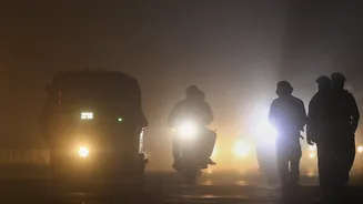

New Delhi: A thick blanket of dense fog gripped Delhi-NCR on Friday morning, turning visibility almost zero in parts of the region between 4 am and 5 am.
The fog was so intense that even objects at a distance of around 100 metres became difficult to spot, leaving commuters struggling through slow traffic and low-visibility stretches. The national capital has been witnessing harsh winter conditions this week, with foggy mornings becoming routine and cold wave conditions reported at multiple locations.
Fog Blanket Over Delhi: Moti Bagh, Dwarka Among Affected Areas
A thick layer of fog enveloped Delhi on Thursday morning, reducing visibility across several parts of the city including Moti Bagh and Dwarka. The foggy spell also impacted aviation, leading to delays in a few flights at the Indira Gandhi International (IGI) Airport.
With visibility dropping sharply during early morning hours, residents were advised to drive carefully, keep headlights on and avoid speeding.
IMD Issues Yellow Alert, but Relief Expected From Friday
The India Meteorological Department (IMD) issued a yellow alert, warning of cold wave conditions at isolated places.
However, there may be some relief from Friday onward as cold wave conditions are expected to weaken due to a feeble western disturbance, which could raise night temperatures slightly.
How Cold Will it Get? Temperature Outlook For the Weekend
IMD has forecast:
- Minimum temperature on Thursday: between 3°C and 5°C
- Minimum temperature on Friday: between 6°C and 8°C
- Minimum temperature by Sunday: expected to rise further to 8°C–10°C
Day temperatures, meanwhile, have provided slight relief. Delhi recorded a maximum of 20°C on Wednesday, close to normal. On Tuesday, the maximum touched 21.6°C.
#WATCH | Delhi: A thick layer of fog engulfs the national capital. Visuals from ITO. pic.twitter.com/ecGkHY5yNn
— ANI (@ANI) January 16, 2026
What Counts as a Cold Wave? IMD Explains
According to IMD norms, a cold wave is declared when:- the minimum temperature falls below 10°C and is 4.5°C or more below normal, or
- the actual minimum temperature drops to 4°C or lower
An IMD official said, “Multiple stations reported cold wave conditions on Wednesday.”
Weather experts say a western disturbance is expected to start affecting the Himalayan region from January 15, with fresh snowfall likely on January 16.
Wind direction is also likely to shift to easterly, which can increase moisture levels in the air — meaning more fog potential, but slightly milder nights.
Meanwhile, Skymet vice-president Mahesh Palawat said a second stronger system could bring rain later in the month. “A second, more active western disturbance is, meanwhile, expected to bring possible rain across the plains on Jan 22 or 23,” he said.
Air Quality Remains ‘Very Poor’, Likely Till January 23
Along with the biting cold, Delhi continues to battle severe pollution.The city’s air quality stayed at the higher end of the “very poor” category on Wednesday.
- 24-hour average AQI: 353
- Tuesday AQI was 360
Forecasts suggest AQI will remain very poor at least until January 23, keeping health concerns high for children, the elderly and those with breathing issues.
(With news agencies inputs)