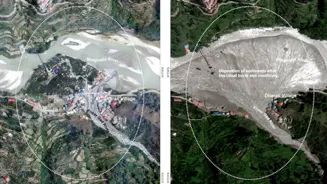


Days after catastrophic flash flood triggered by intense rainfall ravaged Dharali and Harsil villages in Uttarkhand, the Indian Space Research Organisation
(ISRO) released a satellite image showing the devastation in the region. At least five persons were killed and over 100 reported missing as the sudden deluge swept away homes, buildings, bridges, roads, and claimed human lives in the Uttarkashi district on Tuesday afternoon. The satellite images are guiding ground teams in the relief operations. The very high-resolution satellite images by Cartosat-2S satellites - shared by ISRO on X - reveal the extent and severity of the destruction. The comparative analysis of satellite images indicate altered river morphology and damage to human lives and infrastructure. A number of buildings appear to be submerged with mud / debris, in Dharali village.
"Fan-shaped deposit of sediment & debris at Dharali village (~20ha area, ~750m X ~450m), at the confluence of the Kheer Gad & Bhagirathi River.
Partial / complete destruction and disappearance of several buildings in the flood-affected zone, likely submerged or swept away by the intense mud flow and debris.
A number of buildings appear to be submerged with mud and debris in Dharali village.
"The satellite images would help the ongoing search & rescue operations to reach out to stranded individuals and restore connectivity to the isolated region. The event highlights increasing vulnerability of Himalayan settlements to disasters. Scientific analysis is being carried out to ascertain the cause of the triggering event," it said.
Priority to Airlift Advanced Equipment to Dharali, Says Official
Rescue officials are racing against time to trace those trapped under rubble and rescue pilgrims stranded at various locations in the district due to breached and blocked roads.
"Our priority today is to airlift advanced equipment to the spot. Our teams coming with advanced equipment on Wednesday were held up due to blocked roads," State Disaster Response Force (SDRF) IG Arun Mohan Joshi told news agency PTI.
There are 50 to 60-ft-high mounds of debris and those missing may be trapped under them, he said.
The advanced equipment will help rescuers dredge through the huge volume of rubble in search of the missing.
Another priority is rescuing pilgrims stranded at different locations because of blocked roads. Their number could be 300-400, Joshi said.
Dharali is the main stopover on the way to Gangotri, from where the Ganga originates, and is home to several hotels and home stays.
Ground penetrating radars and sniffer dogs are also likely to be used to trace the missing, the officials said.
Rescuers recovered two bodies on Wednesday.
Chief Minister Pushkar Singh Dhami is camping in Uttarkashi to closely monitor rescue operations, which would gain momentum when the weather improves and the blocked roads are opened.
Landslides have blocked arterial roads leading up to Dharali, where dozens of people were trapped and many homes and cars swept away in the flash floods triggered by a cloudburst on Tuesday. Eleven Army personnel from a nearby camp in Harsil are among those missing.