
Hurricane Melissa, now a Category 4 storm, is expected to intensify further, posing a threat to Jamaica and other Caribbean islands. Forecasters say the hurricane
could reach Category 5 strength, with winds exceeding 150 mph, in the coming days. As it moves northwest through the Caribbean Sea, Melissa is expected to bring damaging winds, heavy rainfall, life-threatening flash flooding, and the risk of landslides to Jamaica. The National Hurricane Center (NHC) said the strongest winds would hit early in the week, though catastrophic conditions could begin sooner. A hurricane warning was in effect for Jamaica, with the slow-moving storm located about 110 miles off the coast of the capital, Kingston. The NHC said Melissa is expected to make landfall between late October 27 and early October 28 as "an upper-end Category 4 hurricane, which could be the strongest direct landfall for the island" since records began. Hurricane researcher Michael Ferragamo said on X: "When Hurricane Melissa makes landfall in Jamaica, it'll be only the 5th major hurricane on record to strike the nation. With a forecast landfall speed of 150 mph, the storm would easily surpass the island's strongest on record." The strongest previous storm was Hurricane Gilbert, which struck as a high-end Category 3 in September 1988. Also Read: Will Hurricane Melissa be the Strongest Storm Ever to Hit Jamaica? Melissa is forecast to make landfall near the Jamaican coast by October 28 before moving across the island and over eastern Cuba. Forecasters warned that the storm is likely to remain a major hurricane as it reaches Cuba by midweek. Haiti, the Dominican Republic, parts of Cuba, the Bahamas, and the Turks and Caicos could face life-threatening flash flooding and the potential for landslides later in the week as the storm passes through the region, the NHC said.
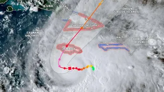
Where is Melissa Headed?
AccuWeather reports that Melissa is expected to continue through the Bahamas as a Category 5 hurricane before moving into the Atlantic, potentially affecting Bermuda. On exiting the Caribbean, the storm is forecast to shift closer to the East Coast of the United States. While no serious damage is expected there, it could indirectly affect the region in the final days of October and early November.