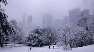

New Yorkers who spent Friday stocking up on groceries and charging their phones woke up Saturday to a pleasant surprise: far less snow than feared. The
powerful winter storm, the heaviest to strike the Tri-State region in almost four years, delivered less snowfall than had been forecasted earlier. Central Park officially recorded 2.3 inches, while Kennedy Airport measured 2.5 inches and Fordham in the Bronx tallied 4 inches. Just beyond the city limits, however, the storm lived up to its billing. Communities north and east of New York City bore the brunt. According to a report from ABC News, in Connecticut, New Fairfield led the way with 9.1 inches, followed by Fairfield at 7 inches and Newtown at 6 inches. Long Island saw similar amounts, with North Patchogue reporting 6.8 inches and Hampton Bays checking in at 6.5 inches. The Hudson Valley also caught decent snow, including 6.5 inches in Lake Carmel, 6.4 inches in Armonk, and 6.1 inches in Peekskill. New Jersey, like much of the city, ended up on the lighter side. Springfield picked up 3 inches, and Newark saw 2.5 inches. Saturday’s temperatures are expected to stay below freezing all day, meaning any cleared pavement could quickly refreeze. Transportation officials are asking drivers to remain cautious and watch for black ice, especially on secondary roads and bridges. While the cleanup continues, many city residents are breathing a sigh of relief after escaping the worst of what could have been a far messier weekend.