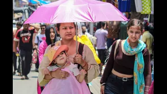


As large parts of India reel under an intense heatwave this May, temperatures are climbing to dangerous levels across the north and central regions. Banda in Uttar Pradesh recorded a scorching 48°C on Wednesday,
making it the hottest place in the country, while Delhi has been hovering around 44–45°C under repeated heatwave warnings from the India Meteorological Department (IMD).
For millions, the heat has brought exhausting days, rising health risks, water shortages and disrupted routines. Yet, despite the discomfort, this brutal pre-monsoon heating is also one of the key reasons India receives its annual monsoon rains.
The same weather pattern pushing temperatures to dangerous levels is simultaneously helping build the atmospheric setup that draws moisture-laden winds towards the Indian subcontinent every year.
Why Does India Become So Hot Before The Monsoon?
India’s pre-monsoon summer, especially across the northern and central plains, is naturally one of the hottest periods of the year.
During May and early June, the Sun heats the Indian landmass rapidly. With clear skies, dry conditions and little rainfall, the ground absorbs heat quickly. Land surfaces warm much faster than surrounding oceans, particularly the Arabian Sea and the Indian Ocean.
As the land heats up, the air above it rises. This creates a vast low-pressure zone over northwest India and adjoining parts of Pakistan, often referred to by meteorologists as the “heat low”.
At the same time, the surrounding ocean waters remain relatively cooler and maintain comparatively higher pressure.
This contrast between low pressure over land and higher pressure over the ocean becomes one of the driving forces behind the southwest monsoon.
How Does Extreme Heat Help Bring Monsoon Rains?
The monsoon is essentially a giant seasonal wind system driven by pressure differences.
As the low-pressure zone over India strengthens during late May and early June, it begins pulling in moisture-rich winds from the Arabian Sea and the Indian Ocean towards the subcontinent.
These winds travel thousands of kilometres carrying enormous amounts of moisture.
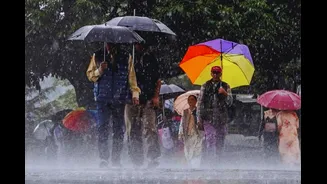
Once they move inland, the hot land surface and rising air currents help push the moist air upward. As the air rises higher into the atmosphere, it cools and condenses into clouds, eventually leading to rainfall, thunderstorms and widespread monsoon showers.
In simple terms, the scorching summer heat helps create the “pull” that draws monsoon winds into India.
Meteorologists say that without strong heating over the landmass, the pressure gradient would weaken, making it harder for monsoon winds to advance effectively.
This is why intense heat over northwest and central India is considered an important part of the monsoon setup every year.
Is More Heat Always Good For The Monsoon?
Not necessarily.
While seasonal heating is a natural and necessary part of India’s monsoon cycle, scientists caution that extreme heat driven by climate change does not automatically translate into better rainfall.
Global warming is making heatwaves more frequent, longer and more intense across South Asia. At the same time, climate change is also disrupting rainfall patterns, increasing the chances of erratic monsoons, sudden cloudbursts, longer dry spells and uneven rainfall distribution.
Meteorologists increasingly view the monsoon as part of a far more complex ocean-atmosphere system influenced by multiple global factors, including El Niño conditions in the Pacific Ocean, Indian Ocean temperatures and shifting wind circulations.
In other words, summer heat helps establish the monsoon system, but excessive warming can also destabilise it.
When Will The Monsoon Arrive In India?
The IMD has forecast that the southwest monsoon is likely to reach the Kerala coast around May 26, nearly a week earlier than its normal onset date of June 1.
The southwest monsoon is India’s primary rainy season and accounts for nearly 70 per cent of the country’s annual rainfall.
Once the monsoon reaches Kerala, it gradually advances northward over the following weeks. Parts of Maharashtra, including Mumbai, are expected to begin receiving monsoon showers around June 2–5.
The rain-bearing winds will then continue moving deeper into the country, bringing cooler conditions and relief to regions currently enduring extreme temperatures.
However, residents of Delhi and much of north India may still have to wait until around the last week of June, roughly close to the capital’s normal monsoon arrival period.
At the same time, forecasters are also watching signs that the broader 2026 monsoon season may not be particularly strong despite the early onset.
The IMD has projected seasonal rainfall at around 92 per cent of the long-period average, while private forecaster Skymet Weather has estimated rainfall at around 94 per cent of the average.
Both forecasts have pointed to the possible development of El Niño conditions later in the season. El Niño refers to the warming of sea surface temperatures in parts of the Pacific Ocean and has historically been associated with weaker or more erratic monsoon rainfall in India.
In other words, while the monsoon may arrive on time or even earlier than usual, meteorologists caution that this does not necessarily guarantee sustained or above-normal rainfall through the rest of the season, particularly during July and August, which are typically the core monsoon months.