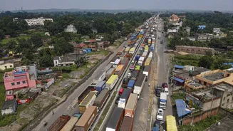


CM Suvendu Adhikari-led Bengal government has decided to hand over seven stretches of national highways to the National Highways Authority of India (NHAI) and the National Highways & Infrastructure Development
Corporation Limited (NHIDCL). Following Nabanna’s in-principle approval, a long-pending deadlock over several national highway projects has been resolved.
WHAT THE STATE NOD MEANS
Responsibility for key roads, including NH-31, NH-33 and NH-312, will now go to NHAI. NHIDCLwill oversee projects such as the Sevok–Coronation Bridge stretch, Hasimara–Jaigaon route and Changrabandha corridor.
These projects had reportedly been awaiting approval from the state government for nearly a year. With clearance now granted, the central agencies will be able to begin road development work at an accelerated pace.
The move is expected to strengthen connectivity across North Bengal and improve links with the Bangladesh and Bhutan borders. The state government claims the decision will significantly improve transport infrastructure in the Darjeeling hills, Dooars and other border areas.
The Chief Secretary has issued the official directive.
WHERE EXACTLY IS CHICKEN’S NECK?
The “Chicken’s Neck” (officially known as the Siliguri Corridor) is a narrow, 22-kilometer-wide strip of land in northern West Bengal, India. It is located around the city of Siliguri and connects mainland India to its eight northeastern states.
It is highly significant because if this corridor were cut off, nearly 50 million people and crucial military logistics in the Northeast would be isolated.
Geographically, it acts as a tight chokepoint flanked by three international borders:
West: Nepal
North: Bhutan
South: Bangladesh
#BreakingNews | The West Bengal government has handed over key highways in the strategically important ‘Chicken Neck’ area to NHAI@KamalikaSengupt shares more details @ShivaniGupta_5 | #NHAI #WestBengal #Highways pic.twitter.com/EGoNim3wIG
— News18 (@CNNnews18) May 19, 2026
WHY MORE LAND NEAR CHICKEN’S NECK MATTERS
Giving more land to the Central Governmentnear the Chicken’s Neck (Siliguri Corridor) means accelerating massive national security, defense logistics, and transport infrastructure projects in India’s most sensitive geographic chokepoint.
This explanation stems from the West Bengal government’s transfer of 120 acres of land in the corridor directly to the Centre.
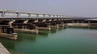
Underground and Expanded Railway Infrastructure: The primary purpose of this land handover is to facilitate a massive railway expansion plan by the Central Government. The Centre plans to upgrade the existing double-track railway to a six-track system. Two of these new tracks will be built as a 40-kilometer underground railway running 20–24 meters beneath the surface between Teen Mile Haat and Rangapani stations.
Moving rail lines underground insulates India’s critical military and supply logistics from external threats like air strikes, heavy artillery, or drone warfare.
Fortifying National Security & Border Control: The Siliguri Corridor is a narrow strip of land in West Bengal—just 20 to 22 kilometers wide at its tightest point—that serves as the only land bridge connecting mainland India to its eight northeastern states.
Because it is bordered by Nepal, Bhutan, and Bangladesh, and sits dangerously close to China’s Chumbi Valley, any blockade here could isolate Northeast India.
Handing land over to central agencies allows the Indian Armed Forces, Border Security Force (BSF), and Ministry of Railways to execute defense fortifications (such as advanced missile deployments and base expansions) without being delayed by state-level bureaucratic friction or political gridlock.
BIG boost for Northeast security & connectivity 🇮🇳
Union Minister Ashwini Vaishnaw has announced an ambitious plan to build 40 km of underground railway tracks along the strategically vital Siliguri Corridor, often called the “Chicken’s Neck”.
The project aims to create a… pic.twitter.com/Xp1nFeE2Uh
— BJP Assam Pradesh (@BJP4Assam) February 4, 2026
Boosting Northeast Development & All-Weather Connectivity: By giving the Centre control of the land and accompanying highway networks (like stretches of NH-31 and NH-312), India can build robust, climate-resilient transit. One freight train carries the equivalent cargo of 300 trucks. Multiplying track capacity ensures a smoother, uninterrupted flow of civil and military supplies to states like Assam and Arunachal Pradesh.
The regionis highly prone to landslides and flooding. Central execution ensures heavy infrastructure is built to withstand extreme weather, maintaining a permanent connection to the Northeast.
With agency inputs