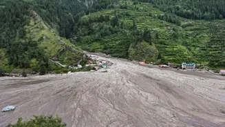

Three days after a massive flash flood hit Uttarakhand’s Uttarkashi, the Dharali village near Gangotri is now buried in debris and sludge. The Indian Army, in close coordination with the Indian Air Force
(IAF), SDRF, NDRF, ITBP, BRO, and civil administration, continues to lead large-scale rescue and relief efforts in the flood- and landslide-affected region of Dharali and Harsil. In some places, the mounds of rubble reach up to 50 feet high, tall enough to completely bury a three-storey building, The Times of India reported.
357 rescued so far: What is the status of Dharali?
Dharaliremains completely cut off due to widespread landslides. However, road clearance efforts have progressed up to Limchigad, where the launch of a Bailey Bridge is currently underway and expected to be completed by Friday evening.
In terms of weather conditions, Matli and Harsil have experienced a period of clear skies, aiding rescue efforts. However, low visibility and rain over Dehradun have temporarily delayed some planned air sorties. “So far, a total of 357 civilians have been rescued, with 119 airlifted to Dehradun. Rescue teams on the ground include Indian Army columns, combat engineers, medical units, and specialised Search and Rescue (SAR) dog squads. The NDRF has deployed 105 personnel, working in tandem with SDRF and ITBP teams, including medical officers stationed in Harsil and Dharali,” said the Indian Army in a statement.
EXPLAINED: Uttarkashi Cloudburst Mayhem: Can Clouds Release Billions Of Litres Of Water In A Minute?
Army doctors, nursing assistants and combat medics are providing on-site treatment to rescued civilians at transit locations. Among the evacuees are 13 Army personnel, while eight soldiers from the 14 Rajputana Rifles remain unaccounted for.
The civil administrationhas reported that approximately 100 civilians are still missing, and two civilian fatalities have been confirmed.
How does the clearing of debris work?
The debris clearance process in Uttarkashi after major floods or landslides is a multi-step, multi-agency operation with significant technical and logistical challenges due to rough terrain, ongoing weather hazards, and the volume of material.
The main steps are:
Assessment and immediate response: Authorities activate disaster response protocols as soon as an incident is reported. Multi-agency rescue teams (Army, National Disaster Response Force—NDRF, State Disaster Response Force—SDRF, local administration) are deployed for immediate search and rescue, supported by helicopters if access is blocked.
Damage and safety survey: Technical committeesare formed, often including district officials, geologists, engineers from the Public Works Department (PWD), irrigation and forest departments, disaster management authorities, and mountaineering experts. They conduct field surveys to assess the danger from unstable slopes, identify safe routes, mark hazardous structures, and recommend if further evacuations are needed.
Search and rescue operations: Sniffer dogs, drones, and manual teams search for trapped or missing people. Locations where people were last seen are prioritized for focused clearance. Residents sometimes assist in identifying likely sites of entrapment.
Deployment of heavy machinery: Once safety is assured, advanced earthmoving equipment such as JCBs and excavators is brought in to remove large boulders, thick layers of mud, and collapsed structures. Road clearance is prioritized to restore critical connectivity. Blocked highways and damaged bridges are cleared or replaced with temporary structures (like Bailey bridges) to reconnect cut-off regions.
Restoration of critical services: Restoration of electricity, water, and communications follows debris removal. Equipment such as generators and relief supplies may be airlifted into isolated areas until road access resumes.
Monitoring and ongoing risk assessment: The situation is monitored using aerial surveys and drones, especially looking for newly formed lakes, fresh landslide risk, or further rising water which could trigger secondary disasters. The central disaster management authorities may order continuous assessment, especially in fragile eco-sensitive zones.
Sustained relief and rehabilitation: Debrisand mud clearance continues in phases, usually starting with accessible and high-priority zones (like highways, hospitals, and main habitation clusters), then progressing to secondary sites.
What are the challenges?
The main challenges faced during debris clearing in Uttarkashi are:
- Sheer volume and depth of debris
- Rugged and remote terrain
- Damaged or destroyed infrastructure
- Ongoing and unpredictable weather hazards
- Limited accessibility for relief equipment
- Fragile ecosystem and safety risks
- Search for survivors among debris
- Disrupted communication and power
What next? Helicopter sorties, Bailey bridge and more
On August 7 alone, 68 helicopter sorties were conducted, including six by the Indian Air Force, seven by the Army, and 55 by civil helicopters. A heli-bridging network has been activated between Dehradun, Harsil, Matli, and Dharasu ALG, supported by C-295 aircraft to ferry critical supplies, rescue teams, and stranded civilians.
To aid coordination, the Indian Armyhas established a Communication Control Room at Harsil, with satellite and Wi-Fi connectivity operational. Meanwhile, BSNL and Airtel are working to restore public mobile networks in the affected region.
Senior military leadership, including the General Officer Commanding, Uttar Bharat Area, and the Commander, 9 (Independent) Mountain Brigade, are on the ground in Harsil to oversee operations and ensure synergy between military and civilian agencies.
The statement said, “The planned actions for August 8, 2025, include the launch of a Bailey Bridge at Limchigad to restore vital road connectivity, the aerial induction of critical relief materials and equipment, continued search operations in Harsil and nearby areas, and the evacuation of remaining stranded civilians by air from Harsil to Matli and Dehradun.”
With ANI, Agency Inputs