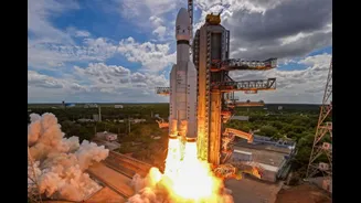








India has taken a major step forward in Earth observation from space. The Indian Space Research Organisation (ISRO) successfully launched the EOS-05 Earth observation satellite aboard the GSLV-F17 rocket
from Sriharikota in the early hours of September 4, 2026.
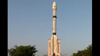
The 51.7-metre-tall GSLV-F17 lifted off from the Second Launch Pad at the Satish Dhawan Space Centre at 2:55 am IST. Around 18–19 minutes later, the approximately 2,367-kg EOS-05 satellite separated from the rocket and was placed into its intended Sub-Geosynchronous Transfer Orbit (Sub-GTO).
That last detail matters. EOS-05 has not simply been dropped into its final 36,000-km geosynchronous position yet. The satellite has entered the transfer orbit from which it will use its own propulsion system to raise its orbit and eventually reach its operational position.
Once commissioned, EOS-05 will become India’s first imaging satellite designed to operate from geosynchronous orbit. That gives India something its conventional low-Earth-orbit Earth observation satellites cannot easily provide: the ability to repeatedly watch a large region of the country from almost the same position in space.
What Makes EOS-05 Different From Other Earth Observation Satellites?
Most Earth observation satellites operate much closer to Earth, often in low or sun-synchronous orbits. They travel rapidly around the planet and can capture extremely detailed images, but they do not continuously remain over one region.
EOS-05 is designed around a very different idea.
At roughly 36,000 km above Earth, a satellite in geosynchronous orbit travels around the planet at the same rate as Earth’s rotation. This means it can repeatedly observe the same broad geographical region instead of waiting for the next orbital pass.
That is the real importance of EOS-05.
ISRO describes EOS-05 as its first-ever imaging satellite from geosynchronous orbit. The mission is intended to provide frequent, near-real-time imagery of large areas, making it particularly useful when something on the ground is changing quickly.
Why The 36,000-Km Orbit Matters
Putting an imaging satellite this far from Earth may sound counterintuitive. After all, being closer to Earth generally makes it easier to capture very high-resolution images.
But EOS-05 is not designed simply to take the sharpest possible photograph. Its biggest advantage is how often it can look at the same region. Imagine a cyclone rapidly strengthening over the Bay of Bengal. A conventional low-Earth-orbit satellite may have to wait for its next pass over the area. EOS-05, once operational from its geosynchronous position, can repeatedly monitor the same broad region and provide rapidly updated imagery.
The same principle can be useful for tracking floods, forest fires, cloud formations, agricultural conditions and other rapidly changing events.
Earlier government information on the GISAT programme described the objective as providing selected sector-wise images at frequent intervals, with the possibility of imaging the entire Indian landmass within about 30 minutes under suitable conditions.
EOS-05 Could Become A Major Tool For Disaster Management
One of the most important applications of EOS-05 could be disaster response.
India regularly deals with cyclones, floods, landslides, forest fires and other natural disasters. In such situations, having updated satellite imagery can help authorities understand what is happening over large areas without waiting for aircraft or ground teams to reach affected locations.
A geosynchronous imaging platform is particularly useful for events that evolve quickly.
For example, satellite observations can help authorities track the movement of a cyclone, monitor cloud development, identify areas affected by flooding and assess changes in vegetation or land after a disaster.
This does not mean EOS-05 will replace India’s existing Earth observation satellites. Instead, it adds a different capability to the country’s growing satellite fleet: high-frequency observation of a large fixed region.
EOS-05 Is Also Important For Agriculture And Environment Monitoring
Earth observation data can be used for monitoring crops, vegetation, soil and environmental changes. Multispectral and hyperspectral imaging can provide information that goes beyond what the human eye sees in a conventional photograph.
Earlier technical information associated with the GISAT programme describes imaging across visible, near-infrared and other spectral bands. The EOS-05 mission is similarly intended to provide spatial and spectral information that can support applications ranging from agriculture and environmental monitoring to disaster management.
This is where EOS-05 could become particularly valuable: instead of simply asking “What does this area look like?”, different spectral observations can help scientists and authorities understand “What is changing in this area?”
A New Capability For India’s Strategic Surveillance
EOS-05 also has an important strategic dimension. A satellite that can repeatedly observe a broad region from geosynchronous orbit can provide persistent monitoring over strategically important parts of India’s land and surrounding waters.
That could strengthen India’s ability to observe developments along sensitive borders and maritime regions. However, it is important not to describe EOS-05 as a dedicated military spy satellite. Its primary classification is an Earth observation satellite, and the technology has both civilian and strategic applications.
Its ability to provide frequent imagery is what makes the mission strategically significant.
EOS-05 Is A Second Chance After The GISAT-1 Failure
The September 4 mission also closes an important chapter in India’s space programme. EOS-05 is associated with the GISAT programme, which was originally conceived to put an imaging satellite into geostationary orbit and provide near-real-time observation of the Indian subcontinent.
In August 2021, ISRO’s GSLV-F10 mission carrying GISAT-1 failed to place the satellite into orbit after a problem during the cryogenic upper-stage operation.
Five years later, EOS-05 has finally carried that broader vision forward. The successful GSLV-F17 mission demonstrates that ISRO has now successfully delivered the replacement spacecraft into its intended transfer orbit.
GSLV-F17: Another Important Part Of The Mission
EOS-05 was launched using GSLV-F17, the 19th flight of India’s Geosynchronous Satellite Launch Vehicle. The rocket used a solid core with four liquid strap-on motors, a liquid second stage and an indigenous cryogenic upper stage.
The mission is therefore another demonstration of India’s ability to use its own GSLV platform to send a relatively heavy spacecraft towards geosynchronous orbit.
ISRO says GSLV-F17 successfully accomplished its mission by placing EOS-05 into the intended Sub-GTO.
What Happens To EOS-05 Next?
EOS-05 was deliberately placed into a transfer orbit rather than directly into its eventual operating position. From there, the spacecraft will perform a series of orbit-raising manoeuvres using its onboard propulsion system.
Once it reaches its final geosynchronous position and completes commissioning, the satellite can begin its operational imaging mission.
This distinction is important because headlines saying that EOS-05 has already reached its final 36,000-km geosynchronous orbit are technically premature. The launch and orbital injection were successful; the satellite’s journey to its final operational orbit continues.
EOS-05 In Numbers
| Feature | EOS-05 Mission |
|---|---|
| Satellite | EOS-05 |
| Mission | GSLV-F17 |
| Launch date | September 4, 2026 |
| Launch time | 2:55 am IST |
| Launch site | Satish Dhawan Space Centre, Sriharikota |
| Launch vehicle | GSLV-F17 |
| Satellite mass | Approximately 2,367 kg |
| Initial orbit | Sub-Geosynchronous Transfer Orbit |
| Operational orbit | Geosynchronous orbit, approximately 36,000 km altitude |
| Primary purpose | Earth observation and frequent imaging |
Why EOS-05 Could Be A Big Deal For India
The significance of EOS-05 is not simply that India has launched another satellite. It represents a shift towards persistent and frequently updated Earth observation.
India already operates one of the world’s major remote-sensing satellite programmes. But those satellites generally observe locations as they pass overhead. EOS-05 adds a complementary capability: staying focused on a broad region and observing changes much more frequently.
That could make a difference during a cyclone, flood or wildfire, when information that is several hours old may not be enough. It could also strengthen agricultural monitoring, environmental assessment, mapping and strategic awareness.