
As scientists investigate the cause of the deadly Uttarkashi flash floods, new satellite images from the Indian Space Research Organisation (ISRO) revealed the massive scale of destruction in the Himalayan
region.
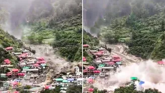
Captured by Cartosat-2S satellite, the high-resolution images from August 7 after the disaster showed a distinct large fan-shaped deposit of mud and debris—spanning nearly 20 hectares (750 m X 450 m)—at Dharali village, where Kheer Gad stream joins the Bhagirathi river.
Satellite Insights Aiding Rescue & Relief Ops
ISRO/NRSC used Cartosat-2S data to assess the devastating Aug 5 flash flood in Dharali & Harsil, Uttarakhand.
High-res imagery reveals submerged buildings, debris spread (~20ha), & altered river paths, vital for rescue teams on… pic.twitter.com/ZK0u50NnYF
— ISRO (@isro) August 7, 2025
The National Remote Sensing Centre (NRSC), Hyderabad, a centre of ISRO, conducted a rapid assessment, comparing the images on August 7 with the available cloud-free pre-event data from June 13, revealing the severity of the destruction.
The images clearly captured the aftermath of the deadly flash floods—widened stream channels and altered morphology of the river, indicating the extensive damage to lives and infrastructure. The destruction is stark with the disappearance of several buildings in the flood-affected zone, likely submerged or swept away by the intense mud flow and debris. “A number of buildings appear to be submerged with mud-debris in Dharali village. The satellite images would help the ongoing search and rescue operations to reach out to stranded individuals and restore connectivity to the isolated region,” said the space agency, drawing attention to the increasing vulnerability of Himalayan settlements to disasters.
However, ISRO noted that scientists are still trying to ascertain the main trigger of the flash floods, and the analysis is currently on. A cloudburst in the upper reaches was initially suspected to be the main trigger; however, there is no conclusive data yet to prove it.
Earlier in the day, a separate analysis done by Uttar Pradesh-based earth observation and space data analytics company Suhora Technologies ruled out Glacial Lake Outburst Flood (GLOF) as the cause of the flash floods. The firm compared the high-resolution satellite images shared by ISRO with its own glacial lake inventory and said there was no glacial lake present upstream of Dharali village. “We acquired the Synthetic Aperture Radar (SAR) imagery at 11:01 PM on August 5th through its platform, SPADE, which delivered the image in near real-time, enabling timely and accurate analysis of the disaster,” it said in a statement.
The catastrophic flash floods on Tuesday caused debris-laden flows over Dharali and Harsil villages in the Uttarkashi district of Uttarakhand, sweeping away homes, buildings, bridges, roads, and claiming human lives. With over six people confirmed dead and many still missing, the giant waves of water swallowed everything in their way. The rescue operation is still on amid incessant rains, with the India Meteorological Department (IMD) predicting heavy rains to continue over the state at least till August 11, with the southwest monsoon still active over the region.