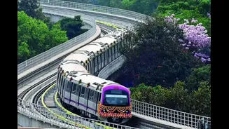


As Bengaluru continues to grow outward with new residential clusters, tech parks and industrial zones, the demand for reliable mass transit has intensified. In response, the city’s metro network is preparing
for a major expansion that aims to significantly widen connectivity across Bengaluru over the next 2 years. Authorities now say the Namma Metro network is on track to reach a total length of about 175 km, almost doubling its current operational footprint.
The expansion is being led by Bangalore Metro Rail Corporation Limited, which is overseeing the completion of multiple corridors currently under construction while planning the next phase of routes to link key growth areas of the city.
Current Network and Expansion Target
At present, the operational length of Namma Metro stands at roughly 96 km, covering parts of north, south, east and central Bengaluru through the Purple and Green lines. With several new corridors and extensions nearing completion, officials aim to add nearly 79 km of new tracks, taking the total network length to around 175 km.
The focus of this expansion is not just increasing route length, but ensuring that large residential and employment hubs that currently depend on road transport gain direct metro access.
Yellow Line to Connect Tech and Residential Hubs
One of the most awaited additions to the network is the Yellow Line, which will connect RV Road in south Bengaluru to Bommasandra in the city’s southeast. This corridor is expected to significantly benefit commuters travelling between areas such as Electronic City, Bommanahalli, Hosa Road and other IT and industrial zones along Hosur Road.
Officials have indicated that trial runs on parts of the Yellow Line are expected to begin in 2026, with phased commercial operations likely to follow once safety approvals are completed. Once operational, this line is expected to reduce travel time between Electronic City and central Bengaluru by a substantial margin.
Pink Line to Improve East-West Connectivity
Another critical corridor nearing completion is the Pink Line, which will run between Kalena Agrahara in the south and Nagawara in the north. This line is expected to connect densely populated neighbourhoods such as JP Nagar, Tavarekere, Dairy Circle, Cantonment area and parts of north Bengaluru.
The Pink Line includes underground sections through central Bengaluru, which have faced construction delays in the past. Officials now say sections of this line are expected to be commissioned in phases, with initial stretches likely to open in late 2026, depending on the completion of underground works.
Blue Line to Link City with Airport Corridor
The Blue Line is designed to connect central Bengaluru with Kempegowda International Airport, addressing one of the city’s longest-standing transit gaps. This corridor will serve areas such as Hebbal, Yelahanka, Jakkur and parts of north Bengaluru before extending towards the airport zone.
Authorities have stated that construction on this corridor is progressing in stages, with operations expected to begin in phases after 2026. Once operational, the line is expected to offer a reliable alternative to road travel for airport commuters, especially during peak traffic hours.
Magadi Road and Western Bengaluru Extensions
The metro expansion also places emphasis on improving connectivity to western Bengaluru. Extensions along Magadi Road are expected to bring metro access closer to areas that have seen rapid residential growth but limited public transport options.
Officials say these extensions will help connect western suburbs to the existing Green and Purple lines, reducing dependence on private vehicles and easing congestion on arterial roads.
Phase III Plans and Tender Timeline
Beyond the corridors currently under construction, Phase III of the metro project is expected to add approximately 45 km to the network. This phase is planned to connect newer residential and suburban pockets such as Sarjapur Road, Hebbal and parts of Outer Ring Road.
BMRCL officials have indicated that tenders for Phase III are expected to be floated in early 2026, following final approvals. Construction timelines for these corridors will depend on land acquisition, funding clearances and contractor mobilisation.
Long-Term Vision for Suburban Connectivity
In the longer term, metro planners are studying potential extensions beyond city limits to areas such as Bidadi, Nelamangala, Devanahalli and Hoskote. While these proposals are still at the feasibility stage, they signal a shift towards integrating Bengaluru’s metro network with its expanding suburban region.
Officials say such extensions could eventually complement suburban rail services and help manage daily commuter traffic entering the city.
What This Means for Commuters
Once the upcoming corridors become operational, metro access will expand deeper into residential, industrial and commercial zones, offering faster and more predictable travel options. Authorities expect the expanded network to ease pressure on major roads, reduce travel times and encourage a shift away from private vehicles.
While timelines remain dependent on construction progress and safety clearances, officials maintain that the push towards a 175 km metro network marks a decisive step towards citywide connectivity for Bengaluru.