


The India-US joint satellite NISAR, launched from Sriharikota in July 2025, has mapped the ground moving beneath Mexico City, which is one of the fastest subsiding capitals in the world.
Jointly built by
scientists from NASA’s Jet Propulsion Laboratory (JPL) in California and Indian Space Research Organization (ISRO), Bengaluru, the NASA-ISRO Synthetic Aperture Radar (NISAR) is one of the most powerful radar systems ever launched into space. While several generations of space-based radars have tracked Mexico City on the move, NISAR has now analysed the fast-changing areas that are challenging to survey from space.
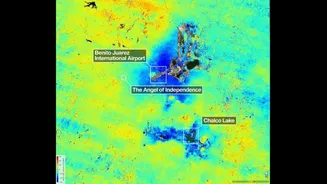
“The findings show how quickly and reliably the NISAR satellite can track real-time changes across Earth’s surface from orbit, unhindered by clouds or vegetation that impede optical sensors and higher-frequency radars,” said JPL in a statement. According to the data provided by the space agency on Thursday, the satellite pin-pointed areas of the city that are sinking by more than half an inch per month due in large part to groundwater pumping. Part of the region found to be subsiding by more than 2cm per month are shown in dark blue.
Home to over 20 million people, the city area is built atop an aquifer—an issue first detected by an engineer in 1925. Extensive groundwater pumping, combined with the weight of urban development, has caused the ancient lakebed beneath the city to compress for more than a century. “Images like this confirm that NISAR’s measurements align with expectations,” said Craig Ferguson, deputy project manager at NASA Headquarters.
The satellite worth $1.5 billion, with NASA accounting for roughly $1.2 billion, is one of the most expensive earth-imaging satellites ever built. While NASA built the L-band Synthetic Aperture Radar, a high-rate telecommunication subsystem, GPS receivers and a deployable 12-meter unfurlable antenna, ISRO built the S-band SAR payload, the spacecraft bus to accommodate both payloads, the GSLV rocket and all associated launch services.
The latest analysis is based on preliminary measurements taken by NISAR between October 2025 and January 2026. The satellite, known to peer straight through the clouds, had earlier captured Seattle and Portland, Oregon which are among the cloudiest cities in the United States.