


As the level of the Mithi river rose to 3.9 meters with the heavy rain in Mumbai, the Brihanmumbai Municipal Corporation (BMC) as a preventive measure evacuated around 350 citizens from the low-lying areas
of Kranti Nagar, Kurla to the temporary shelter in Magandas Mathuram Municipal School. The news, for many, brought back memories of the July 26, 2005 floods. At the time of publishing the report, the level had started to recede and was at 3.6 m. Why is Mithi crucial to keep Mumbai’s life flowing amid rain? What happened in 2005? What has been done since?
What was Mithi’s role in Mumbai’s July 26, 2005 deluge?
The Mithi River is a 14 km-long river flowing through Mumbai, originating from Vihar and Powai lakes and draining into the Mahim Creek, which connects to the Arabian Sea. It serves as a stormwater drain, sewage outlet, and is heavily encroached and polluted.
The Mithi River played a critical and catastrophic role in the Mumbai floods of July 26, 2005, which remain the worst in the city’s history.
As the city received 944 mm rain in 24 hours (644 mm in just 8 hours), the Mithi river breached its banks due to extreme rainfall and high tide. It had no capacity to handle the sheer volume of rainwater and stormwater runoff.
Unchecked construction, slums, and industrial dumping had narrowed the river significantly. Its natural width had reduced from 60-80 meters to as little as 10-15 meters in places.
On that day, high tide at 2:30 PM blocked river discharge into the sea. It led to backflow and flooding in surrounding areas like Kurla, Bandra-Kurla Complex (BKC), Kalina, Vakola, and Dharavi.
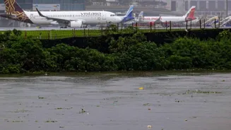
The consequence was air was traffic halted (Mumbai Airport is near the Mithi), roads were submerged, thousands stranded, property destroyed. It contributed significantly to the death tollof over 1,000 in the city.
What has changed in Mithi River since 2005?
Mithi was originally a tidal river and mangrove-lined estuary supporting rich biodiversity. Home to fish, birds, crabs, and natural flood-absorbing wetlands. After the disaster, Mithi River became a symbol of urban neglect. Authorities began cleanup efforts under the Mithi River Development and Protection Authority (MRDPA). Restoration efforts aim to revive its ecological role and restore mangroves.
Steps taken:
Dredging and desilting
Widening the river
Rehabilitation of slums and encroachments
Concrete walls and retaining structures
Bandra-Kurla Complex Pumping Station
Stormwater master plan (BRIMSTOWAD)
Why does Mithi matter?
It acts as a natural stormwater drain for large parts of Mumbai, especially the suburbs.
During the monsoon, it carries rainwater runoff from Powai and Vihar lakes, airports, industrial zones and residential areas. If it’s clogged or narrowed, flooding is inevitable.
It flows right beside the Mumbai Airport, Bandra-Kurla Complex (BKC), and residential neighborhoods. During floods, airports, financial hubs, roads, and railways are directly impacted.
Mithi flooding impacts…
- Bandra-Kurla Complex (BKC)
- Kurla
- Saki Naka
- Vakola
- Parts of Andheri, Mahim, Dharavi
Major flooding events linked to Mithi
2005 (944 mm in 24 hours): Mithi overflowed; blocked by debris; worsened flood in BKC, Kurla
2017 (468 mm in 12 hours): Overflowed again; parts of Dharavi, Sion inundated
2021 (July rains): Mithi swelled dangerously; high tide prevented discharge
2025: Early monsoon flooded Metro stations, BKC, Kurla; major road/rail disruption
Mithi still needs…
Full removal of encroachments
Eco-restoration of the river
Real-time flood monitoring systems
Regular desilting and waste management
BMC’s Korean solution for Mithi
To prevent flooding in the western suburbs, the Brihanmumbai Municipal Corporation (BMC) has plans to set up at least 25 floodgates at various inter-tidal zones in the Mithi River at a cost of Rs 2,300 crore.
The Mumbai project is inspired by the flood control systems used by South Korea, especially in areas prone to immense flooding and tsunamis.
With Agency Inputs