
On February 7, 2021, residents of a few villages in Chamoli heard loud sounds and witnessed huge amounts of mass consisting of rocks, mud, water, and ice blocks roaring down the Dhauli Ganga river, destroying
parts of two hydropower plants in its path. More than 204 people lost their lives, while hundreds went missing. Two years later, over 700 houses across the holy town of Joshimath developed cracks, with water oozing out of walls and roads, exposing massive land subsidence.
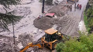
On Tuesday, a massive flash flood devastated Dharali village in Uttarkashi, sweeping away everything in its path, with over a hundred still missing. Just days earlier, on July 31, the state’s disaster management confirmed 17 deaths from severe overnight rains, and landslides all through monsoon.
More than 10 years after the deadly Kedarnath floods shook Uttarakhand, killing thousands, the state remains unprepared as disaster after disaster strikes with little warning.
Each year, the state repeats the same mistakes—cutting down forests, exposing fragile slopes, narrowing river channels and expanding construction deep into the ecologically-sensitive catchment areas.
“Uttarakhand Himalayas are extremely fragile. Rainfall is almost always the trigger. But even when rainfall is not intense, it can still cause slope failure and landslides, especially because the mountain rocks have been weathered, and weakened by repeated freezing and thawing caused by extreme temperature fluctuations. Temperatures in upper altitudes are rising more than in the plains,” said Dr Kalachain Sain, former director of Wadia Institute of Himalayan Geology (WIHG), Dehradun.
With rampant construction of hydropower projects, hotels, roads, and highways—all driven by a booming tourism industry—trees are being felled mercilessly, destabilising the
the hills. Geologists explain how the persistent rains tend to percolate into the subsurface layers, saturating the soil and weathering rock mass.
“In areas where forest cover has been removed, there is little to hold the soil in place. The infiltrated water adds weight to the slope material, making it heavier, which gives in to even a slight disturbance and causes a massive landslide. We all know how dangerous it is during monsoons, when prolonged rainfall, even if moderate, mixes with soil and debris to cause these destructive flash floods,” he added.
Despite ecological concerns, large-scale tree felling, and the fragile, disaster-prone terrain of Uttarakhand, construction activities have continued unabated. A total of 2,969 kms of National Highways have been developed between 2014-15 and June 2025, Union transport minister Nitin Gadkari told Parliament this July.
A centre piece of this is the Union government’s Char Dham National Highway Connectivity Programme to improve road access to four pilgrimage sites of Yamunotri, Gangotri, Kedarnath and Badrinath.
Dr Anand Sharma, former Additional Director-General at IMD, known for predicting the intense rains spell leading up to the Kedarnath floods in 2013, highlighted the failure to ensure early warnings.
“Cloudbursts are challenging to predict. But in Uttarakhand, even 6-7 cms of rainfall can cause water to mix with rock, sediment, soil and come crashing down the slopes. Radars should be able to detect such cloud formations, and that warning be disseminated immediately. These disasters unfold within seconds, so the response time must be immediate. Additionally, why has the construction been allowed in the close catchment areas? Most of these houses in Dharali which got washed away were so close to the stream, and recently built.”
Uttarakhand now has three Doppler weather radars—located in Mukteshwar, Surkanda Devi and Lansdowne—commissioned last year, which can provide data for numerical weather prediction models, particularly for nowcasting (forecast for a few hours). These were also expected to improve rainfall estimation, especially heavy rains.
“What is lacking is a coordinated response during disasters,” remarked Dr M Rajeevan, former secretary of the ministry of earth sciences.
“Even if radar coverage is available, we still need adequate algorithms to predict such extreme events. Technology has advanced, and there must be automated systems to issue real-time Nowcast warnings to alert people. We can no longer afford delays between data analysis and dissemination of information. The major problem is that currently, warnings for rainfall, landslides, flash floods are fragmented – handled by multiple agencies without a unified command, which hampers timely action to save lives.”