


Tropical Cyclone Horacio has intensified into the world’s first Category 5 tropical cyclone of 2026 — the highest possible classification for such storms. The development has drawn global attention, not
only because of its strength, but also because of how quickly it intensified.
Tropical Cyclone Horacio formed over the warm waters of the southern Indian Ocean. Like all tropical cyclones, it began as a low-pressure system over the ocean.
When warm, moist air rises from the sea surface, it creates a low-pressure area beneath. As more air rushes in to fill that space, the system begins to rotate due to the Earth’s spin — eventually organising into a powerful storm.
What makes Horacio significant is the speed at which it intensified. Meteorologists refer to this as “rapid intensification,” a process in which wind speeds increase dramatically within a short period, often due to exceptionally warm sea surface temperatures and favourable atmospheric conditions.
Cyclone Horacio strengthened, with wind speeds rising from about 104 kmph to 257 kmph within 24 hours — a rare and rapid intensification, as reported by the Climate observer.
While Horacio is currently active in the southern Indian Ocean, far from Indian shores, its rapid intensification has raised important questions, including what a Category 5 cyclone is and how vulnerable India is to storms of this magnitude.
What Does A Category 5 Cyclone Mean?
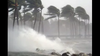
On the widely used Saffir-Simpson Hurricane Wind Scale, a Category 5 cyclone represents the highest type of cyclonic storm with sustained wind speeds exceeding 250 kilometres per hour.
At this intensity, a cyclone has catastrophic destructive potential. Winds at this speed can tear roofs off buildings, uproot large trees, destroy power infrastructure and severely damage coastal settlements.
Such catastrophic cyclones also often generate massive storm surges — walls of seawater pushed inland — leading to severe coastal flooding. Heavy rainfall can also trigger flash floods and landslides far beyond the immediate landfall zone.
How This Cyclone Will Impact India
Currently, there is no indication that Horacio will affect India directly.
The cyclone is located in the southern Indian Ocean, well outside the two primary cyclone-forming basins that typically influence India — the Bay of Bengal and the Arabian Sea. India’s strongest storms usually develop within these northern Indian Ocean regions.
Additionally, tropical cyclones rarely cross from one hemisphere into another. Atmospheric wind patterns and temperature differences act as natural barriers, steering storms within their own ocean basins. This makes it extremely unlikely for Horacio to move toward Indian waters.
There is also no forecast suggesting any indirect weather impact on Indian coastal states at present.
Why India Is Keeping A Watchful Eye
Even when such storms remain far away, they matter for a country like India. With a long coastline of 8041 kilometres, India is one of the world’s most cyclone-vulnerable countries
The subcontinent is exposed to nearly 10 per cent of the world’s tropical cyclones. States such as Odisha, West Bengal, Andhra Pradesh and Tamil Nadu frequently face the brunt of Bay of Bengal cyclones, while Gujarat is exposed to storms forming in the Arabian Sea.
India has experienced extremely powerful cyclones in recent years. In 2019, Cyclone Fani reached Category 5-equivalent intensity and caused widespread devastation in Odisha. Thousands of villages were affected, infrastructure suffered heavy damage, and large-scale evacuations were required.
Events like Horacio serve as reminders of the destructive potential of high-intensity cyclones and the importance of preparedness, early warning systems and climate-resilient infrastructure.
With rising sea surface temperatures in the Indian Ocean, meteorologists have warned that cyclones affecting the region may intensify more rapidly and bring heavier rainfall. This increases the risk of flooding, infrastructure damage and displacement of populations.
While Horacio itself does not pose a threat to India, it fits into a broader pattern of stronger storms globally — a trend that India cannot ignore.