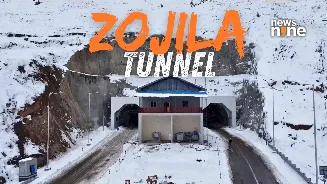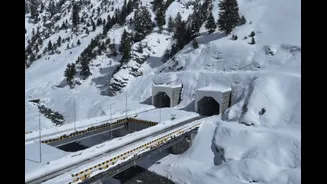


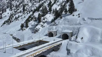
On June 9, engineers achieved the final breakthrough of the Zojila Tunnel, connecting the two ends of what is set to become India’s longest road tunnel and the world’s longest bi-directional road tunnel at such
a high altitude. The final blast of the tunnel may appear to be another infrastructure milestone, but in reality it marks the culmination of one of the most strategically significant engineering projects undertaken in independent India.
For tourists, the tunnel will mean a faster and safer journey to Ladakh. For the Indian Army, it could fundamentally alter the logistics of defending one of the country’s most sensitive frontiers.
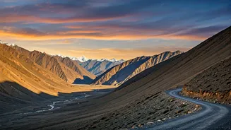
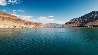
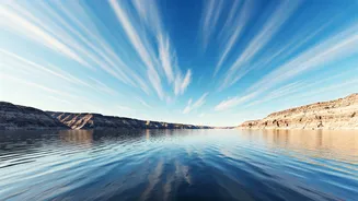
The Zojila Pass sits at around 11,500 feet above sea level on the Srinagar-Leh highway. It is the gateway between the Kashmir Valley and Ladakh. Every winter, heavy snowfall, blizzards, avalanches and landslides shut the pass for months, cutting off Ladakh from the rest of India. For civilians, this means delayed supplies, disrupted transport and isolation.
For the military, it creates a far more serious challenge.
Ladakh hosts some of India’s most sensitive military deployments facing both Pakistan and China. Every winter closure complicates the movement of troops, equipment, fuel, ammunition and heavy military platforms. This is why defence planners have long viewed Zojila not merely as a road project but as a strategic necessity.
What Zojila Tunnel Is All About: The Features
The project’s centrepiece is a 13.153-kilometre single-tube, two-lane tunnel running beneath the Zojila Pass between Baltal in Kashmir and Minamarg on the Ladakh side. The tunnel sits at an altitude of approximately 11,578 feet.
But the tunnel itself is only part of the project. The entire package includes a 13.15-km main tunnel, four bridges with a combined length of about 910 metres, additional Nilgrar tunnels, eight cut-and-cover tunnel sections spanning about 2.35 km, and three massive ventilation shafts reaching depths of approximately 480 metres, 385 metres and 213.5 metres respectively.
The tunnel has been designed as a horseshoe-shaped structure approximately 7.57 metres high and capable of supporting two-way traffic throughout the year.
The project’s cost estimates have evolved over time as designs changed and inflation increased. Current estimates place the cost at over Rs 4,600 crore.
The idea is older than many people realise. Government discussions around an all-weather route through Zojila began in the mid-2000s. The project received approvals years later, with the foundation stone laid in 2018. However, financial troubles at the original contractor and redesigns delayed progress. The contract was eventually re-awarded to Megha Engineering & Infrastructure Limited (MEIL) in 2020. Major construction commenced in 2021.
The delay illustrates a reality of Himalayan infrastructure: building a tunnel is difficult; building one under Zojila is another challenge altogether.
Digging Through One Of The World’s Toughest Mountain Ranges
The Himalayas are young mountains in geological terms. That sounds harmless until engineers begin drilling into them. Young mountains are unstable. Rocks fracture easily. Water seeps unpredictably. Underground pressure changes constantly. Entire sections can become unstable without warning.
Engineers had to deal with fragile geology, water ingress, avalanche-prone terrain, extreme cold, seismic Zone IV conditions, and high-altitude health risks for workers.
Winter temperatures often plunge to minus 18 degrees Celsius, while snow accumulation and avalanches can disrupt work for weeks. Unlike urban tunnels, workers here were operating in thin air with significantly lower oxygen levels.
Even routine tasks become harder.
Machinery loses efficiency. Concrete curing becomes more complicated. Human endurance declines.
Every metre excavated requires extraordinary planning.
The Engineering Method That Made It Possible
The tunnel was excavated using the New Austrian Tunnelling Method (NATM), a technique widely used for difficult mountain tunnelling. Instead of aggressively forcing through rock, NATM works with the mountain itself.
Engineers excavate small sections, continuously monitor geological conditions and immediately reinforce exposed surfaces using shotcrete, rock bolts, steel supports, and continuous geotechnical monitoring. This approach allows adjustments to be made as rock conditions change.
In the Himalayas, where conditions can vary dramatically within a few metres, that flexibility is essential.
The People Behind The Tunnel
Around 1,200 engineers, mechanics, technicians and labourers have been working on the project. They operated simultaneously from both ends of the tunnel – Baltal in Kashmir and Minamarg in Ladakh.
Construction teams worked year-round despite snowstorms, sub-zero temperatures, high-altitude sickness risks, avalanche threats, and geological uncertainties. The breakthrough achieved in June 2026 was not simply the result of drilling. It required years of surveying, blasting, stabilisation, ventilation planning and safety engineering.
Why The Tunnel Matters More To The Army Than Tourists
Tourism headlines often focus on shorter travel times.
The military sees something else. The tunnel removes one of India’s most significant logistical vulnerabilities.
Currently, Zojila Pass closures can severely affect movement between Kashmir and Ladakh during winter. Once operational, the tunnel will ensure year-round connectivity regardless of weather.
That means:
- Faster troop deployment
- Reliable movement of military convoys
- Better supply of fuel and ammunition
- Greater operational flexibility
- Reduced weather dependency during crises
The strategic significance becomes clearer when viewed through history.
During the 1999 Kargil conflict, Pakistan sought to threaten and disrupt the Srinagar-Leh axis because it represented the lifeline connecting Ladakh to the rest of India. Any interruption to this corridor directly affects military logistics.
The Zojila Tunnel effectively provides an all-weather shield to that critical artery.
The Economic Dividend
While defence may be the primary beneficiary, civilian gains are substantial. Today, crossing the Zojila stretch can take up to three hours under favourable conditions. With the tunnel, that journey is expected to take only 20 to 30 minutes.
This translates into lower fuel consumption, reduced transport costs, faster movement of goods, better access to healthcare, improved emergency response, stronger tourism flows, and reduced seasonal isolation of Ladakh. For residents of Ladakh, the biggest benefit may simply be certainty – knowing that winter no longer means months of isolation.
The Zojila Tunnel represents a broader transformation underway along India’s northern frontiers. For decades, harsh geography acted as a strategic disadvantage. Roads shut down. Passes became inaccessible. Military logistics depended heavily on weather.
Projects like Zojila are changing that equation. When the tunnel opens, tourists will notice shorter journeys and safer travel.
Military planners will see something much larger: a permanent all-weather corridor connecting Kashmir and Ladakh, drilled through one of the most hostile mountain environments on Earth.
That is why the true significance of Zojila is not that it is India’s longest road tunnel. It is that India has finally found a way to make one of its most critical strategic routes independent of winter.