


This season, the India Meteorological Department (IMD) will not only track the monsoon’s advance over various parts of the country, but also issue forecasts and alert to farmers at the block-level in as many
as 16 states about its arrival to help them plan their sowing more effectively.
The department has just launched its latest AI-based forecasting system developed in collaboration with the Indian Institute of Tropical Meteorology (IITM), Pune, and National Centre for Medium Range Weather Forecasting (NCMRWF). It has already undergone two successful trial runs. The four-month monsoon season starts in June with its onset over Kerala and covers the entire country by July 8.
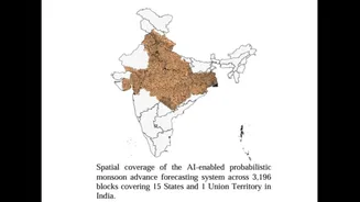
Normally, the monsoon moves across India on dates announced by IMD based on the 1971-2019 data, but its advance within each state, especially at block-level, varies more locally and is harder to track. This is significant not just for farmers, but for local authorities involved in water management—a gap that the new system hopes to address. “We will now provide detailed district-level updates on monsoon’s progress. The first phase covers 15 states and a UT which lie in the core monsoon zone where we have got good results, but we will gradually expand it to other parts of India, as observational infrastructure grows,” said Dr M Ravichandran, Secretary, Ministry of Earth Sciences.
The latest system developed using a combination of numerical weather prediction models and AI-based data-driven approaches is part of IMD’s ambitious push for highly-localised and high-resolution weather forecasts. Farmers across 16 states and 3,067 sub-districts will now receive probabilistic forecast for next four weeks.
UP TO GET MORE LOCALISED RAINFALL FORECASTS
This May onwards, the weather department will also start providing highly detailed rainfall forecasts for the state for Uttar Pradesh. The MeT has also developed an AI-based system that uses dense weather observational network of the state to generate 1 km resolution forecasts up to 10 days in advance. It combines data from weather stations, Doppler radars, satellites, and weather models, and uses AI-driven downscaling to provide more localised alerts.
Currently, the global models run by IMD provide forecasts at 12.5 kms and 3-4 kms resolution with hourly updates. While useful for broad weather predictions, they cannot accurately capture local rainfall patterns needed for precision farming and other localised actions.
“However, the AI model will improve hourly forecasts by refining them from 12.5 km resolution to 4 km and then to 1 km, making them more useful for local planning and precision agriculture. The forecasts will be shared in near real time through APIs and made available on the websites of National Centre for Medium Range Weather Forecasting,” said IMD chief Mrityunjay Mohapatra. “We selected UP as it has the highest density of weather observations in the country. This allows greater use of AI in forecasting.”
Launching the two new services, Union Minister of State (Independent Charge) for Science & Technology and Earth Sciences, Dr Jitendra Singh, said it marks a major shift from conventional weather forecasting towards impact-based and decision-support forecasting. “The changing climate patterns and increasing extreme weather events have made precise and timely forecasting more important than ever before. The AI-enabled monsoon advance forecasting system will provide probabilistic forecasts of monsoon progression every Wednesday up to four weeks in advance. This would be particularly useful for agriculture, water resources, renewable energy, urban planning, disaster management and infrastructure sectors, and help farmers take more informed decisions,” he said.