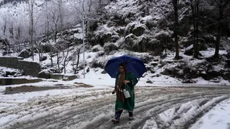


Night temperatures across Kashmir remained below freezing, even as the mercury rose slightly in several parts of the valley with the onset of Chillai Khurd, the milder phase that follows the harshest stretch of winter. The change marks the end of the 40 day Chillai Kalan and the start of a shorter, relatively less severe cold spell, though the weather office has cautioned that fresh rain and snowfall are likely in the coming days.
Night temperatures across key locations
In Srinagar, the minimum temperature on Friday night was recorded at minus 0.1 degrees Celsius, compared to 1.3 degrees Celsius the previous night, remaining about half a degree above the season’s average. Gulmarg in Baramulla district was the coldest recorded place in Jammu and Kashmir, with the ski resort registering a low of minus 6.5 degrees Celsius, a noticeable rise from the extreme minus 10.6 degrees reported a night earlier. In south Kashmir’s Pahalgam, the thermometer settled at minus 2.6 degrees Celsius, up from minus 5.3 degrees, signalling a slight easing of the intense chill.
Variation in southern and northern belts
Qazigund, often described as the gateway to the valley, recorded a minimum of minus 2.2 degrees Celsius, compared with minus 0.3 degrees the previous night. Kokernag saw the temperature dip to minus 3.0 degrees Celsius, while Kupwara in north Kashmir registered a low of minus 2.5 degrees Celsius. Data for some higher reaches such as Sonamarg in Ganderbal district was not immediately available, but officials noted that conditions there remain significantly colder given the elevation and lingering snow cover.
Seasonal phases of winter in the valley
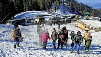
With the conclusion of Chillai Kalan, traditionally considered the harshest 40 day winter phase, the valley has now entered the 20 day Chillai Khurd, also known as the small cold. This period is usually followed by the 10 day Chillai Bachha, or baby cold, which gradually leads into early spring conditions. Residents typically associate Chillai Khurd with marginally softer temperatures, though freezing nights and icy mornings remain common, especially in the higher and interior areas.
Forecast of clouds, rain and snow
The meteorological department has predicted generally cloudy conditions over the next few days, along with a likelihood of light to moderate rain or snowfall, particularly over higher reaches, accompanied by thunder or gusty winds at several places on Saturday and Sunday. Officials added that on 2nd and 3rd February, light rain and snowfall in the upper reaches is expected. While the most severe part of winter is now over, authorities and residents remain alert to possible disruptions from fresh spells of snow and wet weather.