


Heatwave Easing Soon
Following days of scorching temperatures and uncomfortable humidity, Kolkata and the broader South Bengal region are poised for a significant weather transformation.
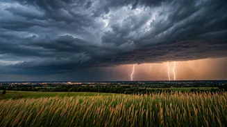
The India Meteorological Department (IMD) has issued a bulletin predicting an increase in thunderstorm activity across the state from April 5 to April 9. This period is expected to mark the commencement of the seasonal Kalbaishakhi storms, which will bring essential rain, dramatic lightning displays, and brisk winds to numerous districts. The preceding hot and humid conditions, exacerbated by dry winds and high moisture content, particularly in coastal areas reaching 80-90% relative humidity, have created a fertile ground for these convective storms to develop. Weather experts anticipate this atmospheric build-up will lead to a welcome drop in daytime temperatures, potentially by 3-4 degrees Celsius within the next 24 hours, thanks to the anticipated rainfall and cloud cover.
Thunderstorms Sweep In
The much-anticipated Kalbaishakhi storms are set to make their presence felt across Kolkata and its neighbouring districts, including Howrah, Hooghly, and the two 24 Parganas. From April 6 through April 9, these areas can expect thunderstorms accompanied by robust gusty winds, reaching speeds of 40-50 kmph, along with significant lightning activity. The IMD's detailed district-wise forecast indicates that the intensity of rainfall will peak around the middle of the week. While Kolkata anticipates primarily clear to partly cloudy skies in the immediate 24 hours, with a possibility of thundery developments in the afternoon or evening, temperatures will likely hover between 36-37 degrees Celsius during the day and 26-28 degrees Celsius at night, all while humidity remains high and rainfall is negligible for now. However, the shift is imminent, promising a cooler, albeit more dramatic, weather pattern.
South Bengal's Relief
Starting from Sunday, the thunderstorm activity is projected to gradually intensify, initially affecting districts such as Purulia, Bankura, Jhargram, and West Midnapore. The storm system is then expected to expand its reach, encompassing other parts of South Bengal, including the metropolitan city of Kolkata, from April 6 onwards. Residents across most districts can look forward to light to moderate rainfall, punctuated by thunderstorms and lightning. Wind speeds are generally forecast to be between 30 and 50 kmph, with the IMD issuing a yellow alert for the region. The period between April 7 and April 8 is anticipated to be the most intense, with some areas potentially experiencing gusty winds soaring up to 60 kmph. Districts like Bankura, East and West Burdwan, Birbhum, and Murshidabad are particularly vulnerable to these stronger winds. Adding to the intensity, isolated hailstorm activity is also a possibility in places like Bankura, East Burdwan, and Birbhum, signaling a robust Kalbaishakhi spell after the prolonged hot and humid spell.
North Bengal Forecast
The weather patterns are set to mirror those in the south across North Bengal's districts. Areas such as Darjeeling, Jalpaiguri, Coochbehar, and Alipurduar are also expected to experience thunderstorms. These storms will bring wind speeds ranging from 30-40 kmph, potentially gusting up to 60 kmph, alongside significant rainfall measuring between 7–11 cm in some regions. Hailstorms are also forecast for isolated locations, with Darjeeling and Jalpaiguri districts being particularly susceptible between April 7 and April 9. Due to the potential for severe weather, an orange alert has been issued for these northern districts, highlighting the need for heightened caution. Residents in both North and South Bengal are advised to take preventive measures, such as avoiding prolonged outdoor exposure between 11 am and 4 pm, staying hydrated, and being aware of the risks associated with lightning strikes, potential damage to temporary structures, falling tree branches, and disruptions to power and communication lines, as well as possible traffic congestion and reduced visibility in urban areas during intense downpours.