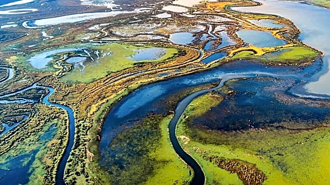










The Okavango Delta, located in Botswana, stands as a remarkable geographical phenomenon, often referred to as the world's second-largest interior delta. Covering an expansive area of approximately 18,000 square kilometers, this region is not a traditional delta with a maritime mouth, but rather an alluvial cone. Each year, about 11 cubic kilometers of water, originating from the Angolan highlands, flow into this endorheic system, dispersing into the Kalahari
Desert and irrigating a vast 15,000 square kilometer area. This unique hydrological cycle and geological history make the Okavango Delta a fascinating subject of study and a vital ecosystem.
Geological Origins and Formation
The Okavango Delta's current form is a result of millions of years of geological and climatic changes. Around 2.5 million years ago, the area was home to the vast Lake Makgadikgadi, which collected water from the Okavango, Cuito, and even the Zambezi rivers. As the climate became drier, this immense lake eventually split into two main parts. The northwestern section evolved into the present-day Okavango Delta, while the other part became the system of dried-up Makgadikgadi pans.
These two systems remain connected by a waterway known as the Boteti. The delta itself is situated within the Okavango graben, a geological depression where up to 600 meters of sediments, carried by the river, have accumulated. This accumulation stopped against a fault line, which is now marked by the Thamalakane River. Over the last 500,000 years, as the Okavango Lake receded, it freed the Zambezi River, allowing it to find its own path to the sea.
Water Dynamics and Unique Features
The Okavango Delta's water is remarkably pure, largely due to the minimal presence of agriculture and industry along the Okavango River's banks. However, as this pure water flows through the sandy aquifers of the delta's numerous islands, it undergoes significant evaporation, leaving behind substantial quantities of salt. This salt saturation is so high that vegetation is often absent in the center of these islands, where salt crusts form.
The region experiences cyclical flooding, with waters inundating the area during the austral mid-summer and reaching the southern parts about six months later, typically in May-June. The high temperatures in the region lead to rapid evaporation, creating fluctuating water levels. This dynamic environment means that islands can disappear under the floodwaters during peak inundation periods, only to reappear as the water recedes. The Magweggana, or Selinda spillway, located northeast of the delta, still connects the Okavango to the Kwando and, consequently, to the Zambezi, especially during the height of the flood.
The Formation of Islands and Ecosystem Support
Millions of islands dot the landscape of the Okavango Delta. Many of these islands form around termite mounds or clusters of vegetation that trap alluvial deposits. These islands provide crucial habitats within the watery expanse. For instance, twenty-four species of wading birds nest on these islands. Some colonies are established on "gomoti," an aquatic fig tree that also provides shelter for crocodiles and hippopotamuses. This intricate interplay of water, land, and life underscores the delta's significance as a natural wonder.