








Hurricane Sandy, a significant Atlantic tropical cyclone, left a lasting impact on parts of the Caribbean, Mid-Atlantic, and Northeastern United States in late October 2012. Its journey began as a tropical wave and evolved through various stages, including rapid intensification, multiple landfalls, and a unique transformation into a hybrid cyclone often referred to as a "Superstorm." This meteorological history showcases the complex interplay of atmospheric
conditions that shaped one of the most impactful storms of its time.
Genesis and Early Development in the Caribbean
The origins of Hurricane Sandy can be traced back to October 19, 2012, when a tropical wave was observed moving westward through the eastern Caribbean Sea. This system was characterized by an extended low-pressure area and was expected to become more organized. By October 20, the National Hurricane Center (NHC) noted its improved organization and a high potential for it to develop into a tropical cyclone within 48 hours. Despite small thunderstorms initially, the barometric pressure in the area remained low, indicating continued potential for development. The thunderstorms eventually grew larger, and the system's movement slowed, eventually becoming stationary.
On October 22, at 1500 UTC, the NHC issued advisories on Tropical Depression Eighteen, located approximately 320 miles south of Kingston, Jamaica. The depression formed in an area with weak steering currents, situated south of a ridge extending eastward from the Gulf of Mexico. The environment was favorable for strengthening, and later that day, a Hurricane Hunters flight detected winds of 40 mph in a rainband, leading the NHC to upgrade the depression to Tropical Storm Sandy. The moist atmosphere further contributed to the storm's increasing organization.
Intensification, Landfalls, and Structural Changes
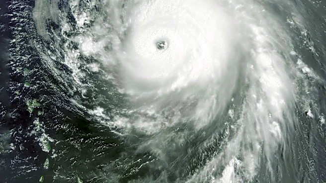
By early October 24, an eye began to develop within Sandy, which was then moving slowly northward. At 11:00 am EDT (1500 UTC) on October 24, the NHC upgraded Sandy to hurricane status after Hurricane Hunters found winds of 99 mph. At this point, Sandy was about 65 miles south of Kingston, Jamaica. The hurricane made its first landfall near Kingston at 3:00 p.m. EDT (1900 UTC) on October 24, with winds around 80 mph.
After a brief period over Jamaica, Sandy moved just offshore Cuba and underwent a period of rapid intensification, strengthening into a Category 3 hurricane on the Saffir-Simpson hurricane wind scale. It had 1-minute sustained winds of 115 mph and a central pressure of 954 millibars. Operationally, it was classified as a high-end Category 2 hurricane at landfall. Shortly thereafter, at 0525 UTC on October 25, Sandy made its second landfall just west of Santiago de Cuba. At this time, it possessed a well-defined eye over 23 miles in diameter, and flight-level winds reached 135 mph. While over land, the storm's structure deteriorated, and the eye became no longer visible. After exiting Cuba, a combination of dry air and increasing wind shear caused the storm to become disorganized, restricting its outflow. A mid-level low over Florida and an approaching trough turned the hurricane toward the north-northwest.
Hybridization and Dissipation
By early October 26, most of the convection associated with Sandy was located north of its center, primarily due to wind shear and dry air to the southwest. The storm's size had significantly increased, with tropical storm-force winds extending approximately 275 miles from its center. As the day progressed, Sandy continued its slow northward movement, and strong wind shear caused a slight decrease in its intensity. On October 27, the NHC noted that Sandy was "showing characteristics of a hybrid cyclone," resembling a large occluded frontal low. However, it maintained a warm thermal core and continued to develop thunderstorms due to divergence from a nearby trough. This trough began to phase with Sandy, contributing to its transformation into what many called a "Superstorm." Sandy briefly weakened to a tropical storm on October 27 as dry air became fully ingested into its mid- and upper-level circulations, but later that day, Hurricane Hunters data indicated it had re-intensified into a minimal hurricane.
After moving ashore in the United States, Sandy continued westward, weakening below hurricane force by the time it reached Pennsylvania. The Weather Prediction Center (WPC) took over advisories as the system became non-tropical. The remnants of Sandy brought heavy snow and high winds to the central Appalachian Mountains, leading to blizzard warnings. The system continued to weaken over western Pennsylvania, and by 0300 UTC on October 31, its movement shifted to the northwest. Blizzard conditions persisted in the Appalachians, adding more snow to already affected areas. By 0900 UTC on October 31, the circulation degenerated into a trough of low pressure with no discernible center. Later that day, Sandy's remnants spread into the Great Lakes, and the WPC issued its final advisory. Nearly three feet of snow fell in some areas of West Virginia, Tennessee, and Maryland, with lesser amounts elsewhere. Over the next two days, Sandy's remnants drifted northward and then northeastward over Ontario before merging with another low-pressure area over Eastern Canada on November 2.