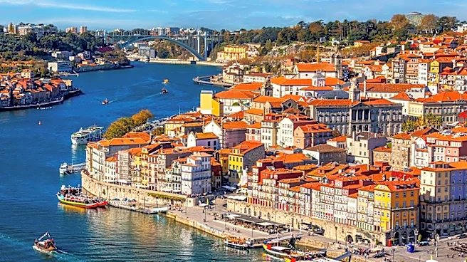






Porto, Portugal's second-largest city, is strategically positioned on the Atlantic coast, specifically on the north bank of the Douro River as it approaches its mouth. This unique geographical placement profoundly influences the city's climate and its overall character. Together with Vila Nova de Gaia, located on the opposite bank of the Douro, Porto forms the core of a metropolitan region home to 1.76 million people, making it the second-largest urban
agglomeration in the country. The city's direct proximity to the ocean and the river shapes everything from its weather patterns to its historical development as a port city.
The city's name, which literally translates to "port" in German, underscores its deep connection to its coastal and riverine environment. This natural advantage has been a defining feature of Porto since its earliest settlements, facilitating trade and communication throughout its long history. The interplay of land and water has not only shaped its economy but also its climate, creating a distinct environment that sets it apart from other regions.
A Warm-Summer Mediterranean Climate
According to the Köppen and Geiger climate classification, Porto experiences a Warm-Summer Mediterranean climate (Csb). This classification is characterized by dry, but not excessively hot, summers and relatively mild winters. The city's direct location on the Atlantic Ocean is a primary factor in moderating its temperatures. This oceanic influence prevents extreme heat in the summer and ensures that winter temperatures rarely drop below 0 °C (32 °F). Snowfall is an even rarer occurrence, making Porto's winters notably temperate.
The climate of Portugal, as a whole, is categorized as maritime and semi-humid within the subtropical climate zone. Porto's specific conditions are further shaped by the cool Canary Current, which flows southward along the Portuguese coast. This current is responsible for frequent coastal fog during the warmer months, adding a distinctive atmospheric quality to the city. In winter, Porto often falls under the influence of Atlantic low-pressure systems, which bring significant rainfall to the coastal areas.
Rainfall Patterns and Riverine Connections
The months with the highest precipitation values in Porto typically span from October to April. The annual average rainfall totals approximately 1267 mm (about 50 inches). This seasonal rainfall, combined with the Douro River, contributes to the lushness of the surrounding landscape and has historically supported the region's agricultural endeavors, most notably the vineyards that produce port wine.
The Douro River is not merely a geographical boundary but a vital artery for Porto. It connects the city to its hinterland, where the grapes for port wine are cultivated. The wine is transported down the Douro to Porto, stored in Vila Nova de Gaia, and then exported worldwide from Porto. This riverine connection, along with the city's Atlantic access, has been fundamental to Porto's economic prosperity and cultural identity, making its geography an inseparable part of its story.