


The Annual Monsoon Maze
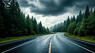
Every year, it’s the same story. From Mumbai’s low-lying areas to Bengaluru’s tech corridors and Chennai’s arterial roads, the monsoon brings life to a standstill. A 20-minute commute turns into a three-hour ordeal. Cars stall in murky water, two-wheelers
are submerged, and pedestrians are left stranded. We’ve all been there: peering out, trying to guess if that patch of road ahead is a shallow puddle or a car-drowning chasm. Official advisories are helpful but often too broad. They can tell you a storm is coming, but they can’t tell you if your specific gully is currently impassable. This hyper-local information gap is precisely what makes urban flooding so disruptive and dangerous.
What Is Crowdsourced Navigation?
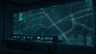
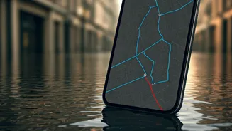
Think of it like Waze, but for waterlogging. The principle is simple yet powerful: a large group of people (a crowd) using a specific app or software contribute small bits of information. In this case, users on the ground report flooded streets, roadblocks, or dangerous conditions directly through their smartphones. The software then collects these real-time reports, plots them on a map, and uses this collective intelligence to suggest safer, drier alternative routes to other users. Instead of relying on a single, central source of information that may be slow to update, this model leverages the eyes and ears of thousands of commuters who are experiencing the situation firsthand.
How Your Phone Helps Chart a Safe Path
When you encounter a waterlogged street, you can open a supported navigation app and mark the area. This can be as simple as tapping a button to report a “Flood” or “Hazard.” Your report, tagged with your GPS location, is instantly sent to a central server. When enough users in the same area report a similar issue, the system’s algorithm confirms the problem and marks the road as blocked or hazardous on the map for everyone. The app’s routing engine will then automatically start diverting other drivers away from that specific stretch of road. It also factors in data like unusually slow-moving traffic—a classic sign of waterlogging—to build a more accurate, dynamic picture of the city’s road network at that very moment.
Tools You Can Use Today
While dedicated “flood-only” apps are still emerging, this functionality is already integrated into platforms you likely use. Google Maps has been improving its ability to show flood warnings and road closures based on both official alerts and user-submitted traffic data. Waze has long had a feature for users to report hazards, including floods, which alerts other drivers. In India, specific state-led initiatives have also appeared, such as Bengaluru’s 'Megha Sandesha' app, which provides real-time information on rainfall and flooding. The key is to not just use your navigation app for directions, but to actively look for these hazard icons and reports on your map before and during your journey. The more people who use these features and contribute reports, the more accurate and reliable the system becomes for everyone.
More Than Just Navigation
The power of this technology goes beyond just helping you get home. When thousands of citizens are mapping floods in real-time, they are creating an invaluable dataset. Municipal corporations and disaster management authorities can use this hyper-local data to identify recurring problem spots that need urgent infrastructure upgrades. It helps them understand the flow of water across the city in a way that traditional models cannot capture. This citizen-led data collection, or 'citizen science', can guide more effective urban planning, leading to long-term solutions, not just short-term fixes. Your simple report on an app contributes to a larger, city-wide effort for better resilience.
A Word of Caution: Use with Care
While incredibly useful, crowdsourced data is not infallible. A route that was clear ten minutes ago might be flooded now. A report might be slightly inaccurate or delayed. This technology should be treated as a powerful aid, not a guarantee of safety. Always combine the app's suggestions with your own judgment. If a road looks dangerously flooded, do not attempt to cross it, no matter what your phone says. Your safety is paramount. Use these tools to make more informed decisions, but never let them override your common sense or official emergency evacuation orders. It’s one tool in your monsoon survival kit, not the entire kit.