








The Planet’s Invisible Framework
Beneath every GPS coordinate, climate model, and map lies the International Terrestrial Reference Frame (ITRF), a massive, globally agreed-upon system for measuring the Earth.. Think of it as the planet’s definitive, ultra-precise grid. This framework
is crucial for everything from navigating ships and planes to monitoring the millimeter-per-year movements of tectonic plates and rising sea levels.. Currently, the ITRF is built by combining data from several independent networks on the ground, including GPS stations, radio telescopes (VLBI), and satellite laser ranging (SLR) systems.. However, tying these separate systems together isn't perfect; tiny errors, known as 'site tie' biases, creep in, limiting the overall accuracy of the global frame.. To track climate change and build next-generation infrastructure, scientists need to reduce these errors from millimeters to sub-millimeters.
Enter GRITSS: A New Eye in the Sky
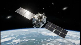
Launched on July 7, 2026, aboard a SpaceX rocket, GRITSS is a suitcase-sized satellite with a big job.. The name stands for Geodetic Reference Instrument Transponder for Small Satellites, and its primary mission is to act as a single, unified reference point in space.. By orbiting Earth, GRITSS can be seen simultaneously by the different ground-based networks—GPS, VLBI, and SLR.. The satellite carries a clever payload that essentially acts as a translator. It receives GPS signals and rebroadcasts them in a format that the VLBI radio telescopes can understand, creating a direct link between two previously disconnected systems.. It also carries a laser retroreflector to be tracked by the SLR network. By providing a common target for all three techniques, GRITSS aims to eliminate the site-tie errors and help scientists achieve an unprecedented 1-millimeter accuracy for the ITRF.
More Than Just a Science Mission
This is where the mission's dual purpose becomes critical. GRITSS is explicitly designed as a technology demonstration.. It’s built as a CubeSat, a class of miniaturized satellites, and packed with advanced components that need to be proven in the harsh environment of space.. These include a geodetic-quality GPS receiver compact enough for a small satellite, an ultra-stable clock to maintain timing accuracy to one-trillionth of a second, and highly stable miniature antennas.. Engineers also had to solve significant thermal control challenges to protect these sensitive instruments from temperature swings of hundreds of degrees as the satellite moves in and out of Earth's shadow.. Proving these technologies work on a relatively low-cost platform like GRITSS is a massive step forward. It de-risks their use for future, more complex missions and accelerates the pace of innovation.
Why This Matters for India
A more precise global geodetic framework has direct benefits for India. The nation's ambitious infrastructure projects, from smart cities to high-speed rail, depend on highly accurate geospatial data.. Furthermore, India's own navigation system, NavIC, and the work of the Indian Space Research Organisation (ISRO) are part of a global ecosystem that relies on a stable and accurate ITRF for its own positioning and earth observation programs.. Improved accuracy helps in everything from better disaster management—by more precisely tracking tectonic shifts and coastal changes—to enhancing agricultural productivity through precision farming.. More importantly, the success of GRITSS as a technology demonstrator validates a model of space exploration that is highly relevant to India: using smaller, cost-effective satellites to test and deploy cutting-edge technology, thereby fast-tracking sovereign capabilities and scientific progress.