








A New 'Eye in the Sky' for India
The Indian Space Research Organisation (ISRO) has successfully placed its EOS-05 satellite into a geosynchronous orbit, a major achievement for the nation's space program. Unlike most Earth-imaging satellites that circle the planet every 90 minutes in Low
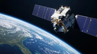
Earth Orbit (LEO), EOS-05 operates from an altitude of nearly 36,000 kilometres. From this vantage point, its orbital speed matches the Earth's rotation, allowing it to seemingly hover over the Indian subcontinent. This unique 'geostationary' capability means it can provide continuous, real-time monitoring of a vast geographical area, a first for an Indian imaging satellite.
The Mission's Crucial Purpose
So, what will EOS-05 actually do? Its primary function is to provide rapid imagery for a wide range of applications. This includes near-real-time monitoring of natural disasters like cyclones, floods, and forest fires, allowing for quicker response and mitigation efforts. The satellite will also be a vital tool for agriculture, helping to monitor crop health, and for climatology, tracking environmental changes. Furthermore, its ability to maintain a constant watch over India's land and sea borders provides a significant boost for strategic and surveillance purposes. In essence, EOS-05 is a multi-purpose guardian, watching over national interests from the sky.
Advanced Imaging and Sensor Technology
The heart of the EOS-05 mission is its sophisticated payload. The satellite is equipped with high-resolution multispectral and hyperspectral imagers. Think of these as cameras with superhuman vision. The multispectral imager can capture light in different visible and infrared bands, allowing scientists to see things the human eye cannot, like subtle changes in vegetation health or water quality. The hyperspectral imager goes a step further, collecting data across hundreds of narrow channels, providing an incredibly detailed 'fingerprint' of the land and water below. Reports suggest it carries the highest-resolution camera ever placed in a geostationary orbit, a remarkable feat of engineering.
The Power of the GSLV Rocket
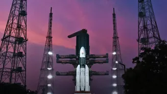
Getting a heavy satellite like EOS-05, weighing over 2,300 kg, to such a high orbit is no small task. This was accomplished by ISRO's powerful Geosynchronous Satellite Launch Vehicle (GSLV). The GSLV is a three-stage rocket, and its most critical component is the indigenously developed cryogenic upper stage. This stage burns super-cooled liquid hydrogen and liquid oxygen as propellants. While incredibly efficient, mastering cryogenic technology is extremely challenging due to the -253°C temperature of liquid hydrogen. The successful flight of the GSLV-F17 with this heavy payload demonstrates ISRO's maturity and self-reliance in complex launch technologies.
From Transfer Orbit to Final Post
The GSLV didn't place EOS-05 directly into its final position. Instead, it injected the satellite into a 'Geosynchronous Transfer Orbit' (GTO) — a highly elliptical path with a low point (perigee) and a high point (apogee). From this temporary orbit, the satellite must perform a series of carefully planned engine burns using its own onboard propulsion system. These manoeuvres gradually raise the perigee and adjust the inclination, circularising the orbit until it reaches its final geostationary slot 36,000 km above the equator. This delicate orbital dance is what the phrase 'reaches near-final orbit' truly means, a critical phase of the mission happening far above the Earth.