






A New Eye in a Unique Orbit
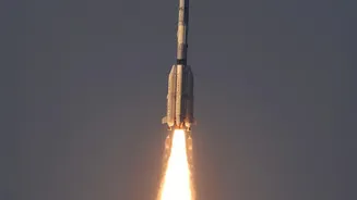
On September 4, 2026, the Indian Space Research Organisation (ISRO) successfully launched the EOS-05 satellite aboard a GSLV-F17 rocket from the Satish Dhawan Space Centre in Sriharikota. The launch was a significant moment for the agency, marking its
first successful mission of the year and a major step forward after previous launch setbacks. What truly sets EOS-05 apart is its destination: a geosynchronous orbit approximately 36,000 kilometres above the Earth. Unlike most other earth observation satellites, which circle the planet in lower orbits and pass over locations periodically, a satellite in geosynchronous orbit moves at the same speed as the Earth's rotation. This allows it to seemingly 'hover' over a single large region, providing constant and uninterrupted observation of the Indian subcontinent and its surroundings.
Unprecedented Monitoring Capabilities
EOS-05 is a game-changer for India's monitoring capabilities. It is the country's first imaging satellite placed in this high-altitude orbit, equipped with powerful multi-spectral and hyper-spectral imagers. One of its cameras reportedly has a resolution of 42 metres per pixel, the highest ever for a camera in geostationary orbit. This technology allows the satellite to provide near real-time imagery of large areas. It can capture an image of a selected area every five minutes and the entire Indian landmass every 30 minutes. This constant stream of data is invaluable for tracking rapidly developing events, a task that is much more difficult for satellites in lower orbits that may only revisit a specific location once every few days.
A Guardian for Disasters and Agriculture
The most immediate and tangible benefits of EOS-05 will be in disaster management and agriculture. The satellite's ability to provide continuous, real-time imagery will fundamentally change how authorities respond to natural calamities. It can monitor the development of cyclones, track the spread of floods and forest fires, and observe cloudbursts as they happen. This constant watchfulness enables faster and more effective emergency response, potentially saving lives and property. For agriculture, the satellite's data will be crucial for assessing crop health, monitoring soil conditions, and managing water resources more efficiently across the country. This kind of detailed, frequent information helps in forecasting yields and ensuring food security.
Strategic and Environmental Applications
Beyond civilian uses, EOS-05 serves important strategic purposes. Often referred to as a 'hawkeye,' its ability to maintain a constant vigil over the Indian subcontinent makes it a vital tool for national security, allowing for 24/7 monitoring of borders and strategic assets. This persistent oversight is a significant enhancement to India's existing surveillance capabilities. Furthermore, the satellite will play a key role in environmental monitoring. It can track long-term changes like the melting of glaciers in the Himalayas, deforestation, and shifts in coastal regions. This data is essential for understanding the impacts of climate change and formulating effective environmental policies. The mission is part of ISRO's broader Earth Observation program, which provides crucial data for resource management and governance.