








The Fury of the Monsoon Surge
For India's vast and densely populated coastline, the monsoon is a double-edged sword. While it brings life-giving rains, it also unleashes ferocious cyclones. One of the most dangerous phenomena associated with these cyclones is the storm surge—an abnormal
rise in sea level caused by the storm's intense winds pushing water towards the shore. This wall of water can race miles inland, causing catastrophic flooding, destroying homes and infrastructure, and leading to significant loss of life. The coastal plains of West Bengal, Odisha, Andhra Pradesh, and Tamil Nadu on the east coast, and Gujarat on the west coast, are particularly vulnerable. The increasing intensity of cyclones due to climate change has only amplified this threat, making accurate and timely warnings more critical than ever.
ISRO's Technological Leap Forward
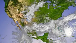
The Indian Space Research Organisation (ISRO), in collaboration with the India Meteorological Department (IMD) and the Indian National Centre for Ocean Information Services (INCOIS), has been at the forefront of improving the country's cyclone warning system. The latest upgrade focuses on enhancing the Storm Surge Early Warning System (SSEWS). This isn't just about one new satellite, but a sophisticated integration of higher-resolution data from multiple platforms like the INSAT-3D, 3DR, and the recently launched INSAT-3DS satellites, along with advanced numerical models. These systems provide a continuous stream of data on cloud cover, wind patterns, and sea surface conditions, which are the essential ingredients for forecasting the birth and behaviour of cyclones. The key to this upgrade is the ability to process this vast amount of information more quickly and feed it into predictive models that simulate storm surge behaviour with greater precision.
From Data Points to Accurate Alerts
So how does it work? The old approach relied on models that, while effective, had limitations in lead time and geographical precision. The new system leverages what is known as impact-based forecasting. Instead of just predicting the height of a potential surge, the upgraded models, powered by supercomputers, can simulate how that surge will interact with the specific topography of the coastline. This includes factoring in river deltas, estuaries, and low-lying areas. By combining high-resolution satellite imagery with advanced computer simulations, forecasters can now generate highly detailed inundation maps, showing which specific villages and neighbourhoods are likely to be affected and to what extent. Recent developments also include the experimental use of Artificial Intelligence and machine learning algorithms to analyse historical data and improve forecast accuracy even further, especially in the crucial 24 to 72-hour window before a cyclone makes landfall.
What This Means for Coastal India
The real-world impact of this technological upgrade is profound. More accurate forecasts translate directly into saved lives and property. With better and more reliable lead times, disaster management agencies can execute targeted evacuations, moving people out of harm's way with greater efficiency and less panic. This has been a key factor in India's journey to drastically reduce cyclone-related fatalities over the last two decades. A forecast that can pinpoint the landfall location with an error margin of just a few dozen kilometres, as opposed to hundreds, means that resources are not stretched thin over a massive area. It allows for prepositioning of NDRF teams, setting up of shelters, and protecting critical infrastructure like power grids and communication lines more effectively. This shift from broad warnings to specific, actionable intelligence is a game-changer for coastal resilience.
Building a More Resilient Future
This upgrade is part of a larger, continuous effort to build a multi-hazard early warning system for the entire country. The collaboration between ISRO, IMD, and INCOIS is a prime example of how scientific expertise can be harnessed for societal benefit. Satellites like those in the INSAT and Oceansat series are the nation's eyes in the sky, providing invaluable data not just for storms, but for monitoring monsoon patterns, agricultural health, and water resources. As these technologies continue to evolve, the goal is to further reduce forecast errors and increase the lead time for all extreme weather events. The improved storm surge forecasting capability is a significant milestone in India's climate adaptation journey, demonstrating a commitment to using cutting-edge technology to protect its most vulnerable communities from the escalating challenges of a changing climate.