


The Annual Monsoon Nightmare
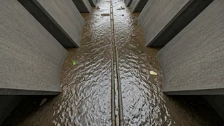
For many Bengaluru residents, the arrival of the monsoon brings a familiar sense of dread. It’s not the rain itself, but what follows: arterial roads turning into impassable rivers, basements flooding, and daily commutes spiralling into hours-long ordeals.
The city’s rapid, often unregulated, urban expansion has put immense pressure on its colonial-era drainage systems. Stormwater drains, or 'rajakaluves', are frequently encroached upon or clogged with garbage and construction debris. When the skies open up, the city’s infrastructure simply can’t cope, leading to predictable yet devastating annual floods.
From Frustration to Innovation
While civic authorities work to address the systemic issues, a proactive group of young professionals, students, and urban activists decided they couldn’t just wait. Fuelled by their own frustrating experiences of being stranded in traffic or having their localities inundated, they channelled their energy into a solution. This collective, comprising software engineers, data scientists, and urban planning students, realised that while the problem was large, information could be a powerful first line of defence. Their idea was simple yet revolutionary: if they couldn't stop the floods overnight, could they at least help people avoid them?
How the Choke Point Map Works
The initiative leverages the power of crowdsourcing and open-source mapping technology. Using a simple web interface or a mobile app, citizens can report drainage blockages and waterlogging in real-time. Each report is a data point, tagged with its GPS location. The team then verifies these reports using a combination of volunteer networks on the ground and cross-referencing with other user submissions. The result is a dynamic, live map that highlights 'choke points'—specific locations where drains are blocked or overflowing, and areas that are currently flooded or have a high historical risk. It’s a digital early warning system, built by the people, for the people.
A Practical Tool for Daily Life
The utility of this map during a downpour is immediate. Before heading out, a resident can check the map to see if their intended route passes through a waterlogged area and plan an alternative path. Delivery services and cab drivers can use it to avoid getting stuck, ensuring faster service and safety. Beyond just navigation, the map also serves as an accountability tool. By logging recurring choke points, it creates a public, data-backed record of civic neglect. Residents can use this data to more effectively lobby their local representatives and municipal bodies like the Bruhat Bengaluru Mahanagara Palike (BBMP) for targeted clean-up and repair work.
Bridging the Gap with Civic Bodies
This initiative isn't meant to be confrontational. In fact, its creators see it as a collaborative tool. The detailed, real-time data collected by citizens can be invaluable for municipal authorities, whose own survey teams can be stretched thin during a crisis. By providing a clear, visual dashboard of problem spots, the map helps the BBMP prioritise its resources, sending de-clogging teams to the most critical locations first. This citizen-led data generation creates a powerful feedback loop, bridging the gap between on-the-ground reality and official response, potentially making civic services more efficient and responsive.