



A New 'Eye in the Sky'
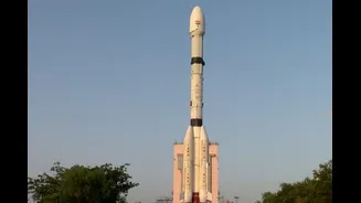
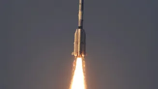
Early on September 4, 2026, the Indian Space Research Organisation's (ISRO) GSLV-F17 rocket lifted off from Sriharikota, placing the 2,367 kg EOS-05 satellite into orbit. This mission is historic as EOS-05 is India's first imaging satellite to be placed
in a geosynchronous orbit, approximately 36,000 km above the Earth. Unlike previous Earth observation satellites in lower orbits that pass over a location periodically, EOS-05 will remain stationary over the Indian subcontinent. This unique positioning allows it to watch over a large area continuously, providing a constant stream of data.
The Geosynchronous Advantage
The key change with EOS-05 is its ability to provide near real-time imagery. While satellites in low-Earth orbit might take days to revisit the same spot, EOS-05 can image the entire Indian landmass every 30 minutes and can be tasked to focus on a specific area of interest for updates every five minutes. This capability is a game-changer for tracking rapidly developing events. The satellite is equipped with advanced multi-spectral and hyperspectral imagers, enabling it to see across different wavelengths of light and capture detailed information about the Earth's surface. One of its cameras reportedly has the highest resolution for any satellite in a geostationary orbit.
Transforming Disaster Management
For a country prone to natural disasters, the implications of EOS-05 are immense. Near-continuous monitoring will fundamentally alter how authorities respond to emergencies like cyclones, floods, and forest fires. Instead of relying on periodic updates, disaster management agencies can now receive a steady flow of images, allowing for better tracking of a cyclone's path or assessing the spread of floodwaters in real time. This constant watch enables quicker and more accurate warnings, more efficient deployment of rescue and relief teams, and ultimately, the potential to save more lives.
A Boost for Agriculture and Environment
Beyond emergencies, the mission provides a massive boost to civilian applications. The data from EOS-05 will aid in monitoring crop health, assessing soil moisture, and managing water resources more effectively. Farmers and policymakers can get timely insights into agricultural conditions across the country. Furthermore, the satellite will be a crucial tool for environmental monitoring, helping to track deforestation, changes in water bodies, and the impact of climate change with unprecedented frequency and detail.
Strengthening Strategic Autonomy
The capabilities of EOS-05 are also vital for national security. A satellite that can provide persistent surveillance over a large region offers significant strategic advantages. It enhances India's ability to monitor its borders and maritime interests, providing high-value data for security agencies. This mission is a major step in bolstering India’s strategic autonomy, reducing reliance on foreign sources for critical Earth observation data and joining an elite group of nations with geostationary imaging capabilities.