


The Viral Spectacle
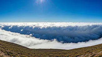
If you spend any time on social media, you’ve likely seen them. The videos are often shot from a high vantage point, looking down into a deep valley. A dense, uniform layer of cloud fills the valley floor like a blanket of snow. In the most dramatic clips,
often sped up through time-lapse, this sea of clouds begins to spill over a ridge or pass, pouring down the other side like a silent, ghostly river. The visuals are hypnotic and have become a staple of travel and nature accounts, garnering millions of views and shares. Captions often express awe, referring to them as ‘cloud waterfalls’, ‘heaven on Earth’, or ‘cloud tsunamis’. While these names capture the visual drama, the reality behind them is a fascinating display of simple physics and meteorology.
What Are We Actually Seeing?
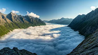
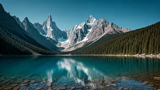
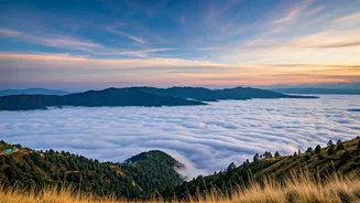
These breathtaking displays are not one single phenomenon but can be caused by a few related meteorological conditions, most commonly valley fog and orographic clouds. The 'cloud wall' or 'sea of clouds' that fills the valley floor is typically a result of a temperature inversion. Normally, the air gets colder as you go higher. But during an inversion, a layer of warm air sits on top of a layer of cooler, denser air trapped in the valley. This cool, moist air at the bottom is unable to rise and disperse. As it cools further overnight, the moisture within it condenses into tiny water droplets, forming a thick, uniform layer of fog or stratus cloud that fills the valley from the bottom up, like water filling a bowl. The tops of the mountains poke out above this 'sea', creating a truly otherworldly landscape.
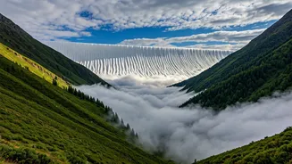
The Science of Cloud Waterfalls
The 'waterfall' effect, where clouds spill over a mountain pass, is a beautiful example of orographic lift. The term 'orographic' simply means related to mountains. This occurs when a moving mass of air—in this case, the wind—encounters a mountain barrier. The air has nowhere to go but up. As this moist air is forced to rise, it cools due to the lower pressure at higher altitudes. This cooling process, known as adiabatic cooling, causes the water vapour in the air to condense and form clouds. When a stable valley fog layer is pushed by a steady wind towards a low point in a ridge, it gets pushed up and over, creating the cascading effect seen in viral videos. The clouds then descend on the other side, often warming up and evaporating as they sink, which completes the 'waterfall' illusion.
India’s Prime Viewing Spots
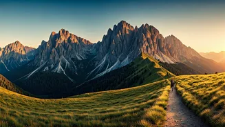
You don't need to travel to the Swiss Alps to witness this magic. The Indian Himalayas are a prime location for these phenomena, particularly during and just after the monsoon season. The valleys of Uttarakhand and Himachal Pradesh are famous for their stunning displays of valley fog. Places like Nainital, Mussoorie, and Shimla, perched at high altitudes, often find themselves above the cloud line, offering residents and tourists spectacular views of the cloud-filled valleys below. In the East, parts of Sikkim and Arunachal Pradesh, with their deep gorges and moisture-rich air coming from the Bay of Bengal, also provide the perfect conditions. The key ingredients are a deep valley, a source of moisture, and calm nights that allow cool air to settle, followed by a gentle breeze to set the clouds in motion.
Why It’s Perfect for Your Feed
There's a reason these cloud walls have become so popular online. The movement is slow and graceful, making it perfect for time-lapse videography, which compresses hours of gentle flow into a dramatic, minute-long clip. The visual is clean, powerful, and universally understood—a force of nature that is both immense and beautiful. It requires no complex explanation to be appreciated, yet it invites curiosity. It’s a reminder of the planet's quiet, persistent power, a spectacle happening in remote valleys whether a camera is there to capture it or not. The digital sharing of this natural art allows millions to experience a moment of wonder, connecting us to the planet's hidden rhythms from the palm of our hands.