




The Challenge of Watching the Waters
For decades, flood forecasting has relied on ground-based methods. Think of river gauges measuring water levels at specific points and meteorological models predicting rainfall. While essential, these tools have limitations. Gauges can be sparse, especially
in remote regions, and can be overwhelmed or damaged precisely when they are needed most. Models, while sophisticated, are making predictions about the future. This system provides a fragmented picture, often leaving communities with little time to prepare for the full scale of an impending disaster.
A New Eye in the Sky
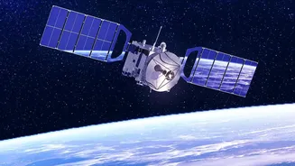
Enter Earth Observation (EO) satellites. These orbital platforms are equipped with advanced sensors that continuously monitor our planet's surface. Instead of sampling data from a few points along a river, they provide a synoptic view, capturing data over vast areas at once. This ability to see the bigger picture, from the swelling of a river basin to the inundation of a coastal plain, is fundamentally changing how we understand and react to flood events. It’s a shift from a reactive to a proactive stance.
Seeing Through Clouds and Darkness
A key breakthrough is the use of Synthetic Aperture Radar (SAR) technology. Unlike optical satellites, which are essentially powerful cameras that can be blocked by clouds or darkness, SAR satellites can see through them. They work by sending out a radar signal and measuring the echo that returns, creating detailed maps of the water on the ground regardless of weather or time of day. This all-weather, 24/7 capability is a game-changer, especially during monsoons when cloud cover is persistent. Missions like the joint NASA-ISRO satellite NISAR and Europe's Sentinel-1 are prime examples of this technology in action. A recent mission, SWOT (Surface Water and Ocean Topography), is even providing unprecedented 3D data on water height, width, and slope, allowing for more comprehensive flood tracking.
A Game-Changer for India
For a country as prone to flooding as India, this technology is invaluable. The Indian Space Research Organisation (ISRO) actively uses its constellation of satellites for disaster management through its Disaster Management Support Programme. During the 2023 flood season, ISRO disseminated around 260 flood inundation maps to state disaster management departments, providing near real-time information for crucial basins like the Brahmaputra and Godavari. The recently launched NISAR satellite has already provided stunningly detailed images of the Brahmaputra in Assam, helping authorities map erosion and channel shifts even through the dense monsoon clouds. This data is integrated into platforms like the National Database for Emergency Management (NDEM), giving decision-makers actionable intelligence to plan evacuations and deploy resources more effectively.
From Prediction to Global Response
Beyond just predicting floods, satellites are crucial for managing the response. When a major disaster strikes, an initiative called the International Charter 'Space and Major Disasters' can be activated. This collaboration between 17 space agencies provides satellite data free of charge to relief organizations on the ground. By comparing images taken before and after a flood, emergency responders can quickly and safely assess the extent of the damage, identify the worst-hit areas, and map out safe routes for rescue teams, often in places that are physically inaccessible. ISRO is a member of this charter and has used it to both receive and provide aid during various disasters.