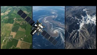









An All-Weather, All-Seeing Eye
NISAR is the result of a landmark collaboration between the Indian Space Research Organisation (ISRO) and the US's National Aeronautics and Space Administration (NASA). Launched in July 2025, it is the first satellite to use two different radar frequencies,
L-band and S-band, to produce incredibly detailed images of Earth's surface. This dual-frequency system gives NISAR a unique superpower: it can see through clouds, darkness, and even dense forest canopies. While optical satellites are blind at night or during heavy monsoons, NISAR's radar technology ensures it can monitor the planet continuously. The satellite will map the entire globe every 12 days, allowing scientists to track changes in our environment with unprecedented precision.
A New Frontier in Flood Management
For a country that frequently battles devastating floods in states like Assam and Bihar, NISAR's capabilities are a game-changer. Its radar can accurately map the extent of floodwaters, even in areas completely obscured by clouds during a cyclone or heavy monsoon. This provides disaster response teams with near-real-time information, helping them direct rescue and relief efforts to the most affected areas more efficiently. Furthermore, by being able to penetrate vegetation, the L-band radar can detect waterlogging in forested or agricultural areas that would otherwise be hidden. This will lead to better damage assessment and more effective planning for flood mitigation in the future, saving both lives and livelihoods.
Revolutionising Indian Agriculture
NISAR is set to become an invaluable tool for India's farmers. The satellite's S-band radar is particularly adept at monitoring croplands. By tracking changes in soil moisture with high resolution, it can provide crucial information for irrigation planning and drought management. Data from NISAR will help create detailed maps showing which areas need water, allowing for more efficient use of this precious resource. It can also monitor the overall health and growth of crops across the country. This information will be vital for predicting yields, setting agricultural policies, and ultimately ensuring national food security.
Watching Over Fragile Slopes
The Himalayas and the Western Ghats are beautiful but geologically fragile regions prone to landslides. NISAR's most remarkable ability might be its capacity to detect tiny, slow-moving changes in the Earth's surface—as small as a centimeter. This technique, known as Interferometric Synthetic Aperture Radar (InSAR), can identify ground deformation that may signal an impending landslide. By spotting these subtle movements in slopes, authorities can issue early warnings to vulnerable communities, potentially preventing catastrophic loss of life. This predictive capability transforms disaster management from a reactive to a proactive approach, offering a new layer of security for millions living in mountainous areas.