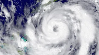




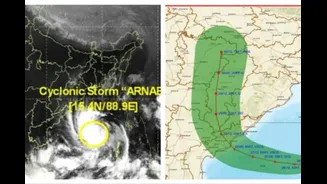


With Very Severe Cyclonic Storm Arnab making landfall along the Andhra Pradesh coast, attention is turning to a secondary, but equally dangerous, threat: the rapid rise of water levels in the region's coastal rivers.
Cyclone Arnab's Landfall and Impact
Cyclone Arnab crossed the Andhra Pradesh
and Yanam coasts on the morning of Wednesday, October 28, as a 'very severe cyclonic storm'. The India Meteorological Department (IMD) confirmed that the landfall process was complete, with the system moving entirely over land. At its peak, the cyclone brought maximum sustained wind speeds of 125-135 kmph, with gusts reaching up to 150 kmph. The storm has already caused significant disruption, uprooting trees and electricity poles, which has led to power outages in many areas. In anticipation of its impact, flight operations at airports including Visakhapatnam, Vijayawada, and Rajahmundry were suspended.
The Threat of River Flooding
The primary concern highlighted in the headline is the swelling of coastal rivers. This happens for two main reasons during a cyclone. First, the torrential rainfall dumps enormous volumes of water into river catchments, which then flows downstream towards the sea. The IMD had forecast heavy to extremely heavy rainfall for coastal Andhra Pradesh and Yanam. Second, a phenomenon known as storm surge, where strong onshore winds pile seawater against the coast, pushes that seawater up into the river channels. This backflow prevents river water from draining into the ocean, causing it to build up and overflow its banks, leading to severe inland flooding in low-lying areas. The IMD warned of a potential storm surge of 1.0 to 1.5 metres.
Which Areas Are on High Alert?
Andhra Pradesh is bearing the direct impact, with the landfall zone stretching between Bapatla and Visakhapatnam. The IMD has issued red and orange alerts for at least 18 districts in the state. Key districts on heightened watch include Visakhapatnam, Kakinada, Konaseema, West Godavari, and Krishna. The threat extends beyond Andhra Pradesh, with heavy rainfall alerts also issued for parts of Odisha, Tamil Nadu, and West Bengal as the storm system moves inland and weakens. In Odisha, districts like Ganjam, Gajapati, and Koraput have been identified as vulnerable. The system's remnants are even expected to bring intense rainfall to northern India and Nepal in the coming days.
How Authorities Are Responding
A massive preparedness and response effort is underway. The National Disaster Response Force (NDRF) and State Disaster Response Force (SDRF) teams have been deployed across the vulnerable states. In Andhra Pradesh and Odisha, tens of thousands of people from low-lying and coastal areas have been evacuated to safer locations and specially prepared cyclone shelters. Andhra Pradesh's Chief Minister, N. Chandrababu Naidu, confirmed that advance precautionary measures helped prevent initial casualties, though two deaths due to electrocution from snapped wires were later reported. Round-the-clock control rooms are active, and all fishing boats were ordered to return to shore. Schools and colleges in at least 14 affected districts in Andhra Pradesh were shut as a precaution.
What You Should Do to Stay Safe
Officials have urged residents in affected areas to stay alert and follow all official advisories. It is critical to avoid unnecessary travel until the cyclone's impact fully subsides. The most immediate danger following the initial landfall is often from secondary effects like flooding and downed power lines. If you are in a lowly or flood prone area be prepared to move to higher ground or a designated shelter if instructed by local authorities. Do not attempt to walk or drive through flooded roads. Stay away from damaged buildings and fallen power lines. For reliable information monitor updates from the IMD the National Disaster Management Authority (NDMA) and local district administration channels. Avoid spreading rumours and rely only on official sources for news.