


The Engine Driving the Rains
So, what exactly is this 'strong Arabian Sea circulation'? Think of it as a massive, organised system of moisture transport. The monsoon, at its core, is a seasonal reversal of winds. During this time of year, the landmass of India heats up faster than
the surrounding ocean, creating a low-pressure area that draws in cool, moisture-laden winds from the sea. The Arabian Sea is a primary source for this moisture for western and central parts of the country. This year, meteorological models have identified a particularly robust circulation, sometimes called a cyclonic circulation or a vortex, forming off the coast. This system acts like a giant, rotating pump. It efficiently gathers moisture from the warm sea surface and propels it eastward over the Indian subcontinent. When these moisture-rich winds hit the land and are forced to rise, they cool, condense, and release their contents as widespread, often heavy, rainfall.
From Sea to Soil in Central India
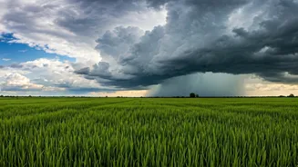
This atmospheric setup has had a direct and potent impact on Central India. States like Maharashtra, Madhya Pradesh, Chhattisgarh, and parts of Gujarat have been at the receiving end of this monsoonal boost. The India Meteorological Department (IMD) often refers to the strengthening of these westerly winds as a key factor for an 'active' monsoon phase. Instead of scattered showers, this circulation promotes the formation of large cloud bands that can deliver sustained rainfall over several days. This has helped the monsoon advance into regions where it was previously delayed or weak, helping to erase rainfall deficits that had accumulated in early June. The result is visible on the ground: rain-lashed cities, rejuvenated rivers, and agricultural lands finally receiving the drenching they need for the Kharif sowing season. This surge is crucial, as the performance of the monsoon in this belt dictates the fate of key crops like soybean, cotton, and pulses.
A Blessing and a Challenge
A strong monsoon is often seen as a blessing, and for good reason. It replenishes reservoirs that provide drinking water and electricity, recharges critically depleted groundwater tables, and brings relief from the scorching summer heat. For the agrarian economy of Central India, timely and abundant rain is the backbone of rural livelihoods. This surge has brought immense relief to farmers who were anxiously awaiting the rain to begin planting. However, this 'boost' is a double-edged sword. The same powerful circulation that brings life-giving water can also deliver it in destructive deluges. The intensity of rainfall can quickly overwhelm urban drainage systems, leading to waterlogging and traffic chaos in cities like Mumbai and Nagpur. In rural areas, intense downpours can cause flash floods, soil erosion, and damage to newly sown crops. It’s a delicate balance; the difference between a 'good' rain and a 'bad' one is often a matter of intensity and duration.
The Bigger Climate Picture
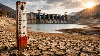
While strong monsoon circulations are a natural part of weather variability, scientists are increasingly studying how climate change is altering their frequency and intensity. Global warming is making the oceans warmer, including the Arabian Sea. A warmer sea provides more 'fuel' in the form of moisture for weather systems like cyclonic circulations, potentially making them more potent. Research suggests that the Indian monsoon is becoming more erratic, characterised by long dry spells punctuated by short, extremely intense rainfall events. This pattern makes water management more challenging, as we need infrastructure that can not only store water for dry periods but also handle sudden, massive inflows to prevent flooding. This year's strong circulation fits into this broader pattern of a more volatile and powerful monsoon system.