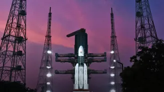







A New 'Eye in the Sky'
At its core, EOS-05 is an Earth-observation satellite, but with a significant difference. Unlike many of its predecessors that circle the Earth in lower orbits and revisit a specific location only periodically, EOS-05 is positioned in a geosynchronous
orbit. At an altitude of nearly 36,000 kilometres, it matches the Earth's rotation, allowing it to stay fixed over the Indian subcontinent. This gives it the unique ability to monitor a large area of interest continuously. Think of it as the difference between a roving patrol and a dedicated sentry on a watchtower. This state-of-the-art satellite, also known as GISAT-1A, is India's first imaging satellite to operate from this high orbit, marking a major milestone for ISRO.
Advanced Tools for a Changing Nation
What makes EOS-05 special is its advanced toolkit. It carries multi-spectral and hyperspectral imagers, which can see the Earth in various wavelengths of light, including those invisible to the human eye. This allows it to gather highly detailed information about our land, water, and atmosphere. The satellite is designed to provide near real-time images, capable of capturing the entire Indian landmass every 30-60 minutes. For specific events like a developing cyclone or a forest fire, it can focus on a smaller region and provide updates every few minutes. This rapid-revisit capability is crucial for tracking fast-moving events and making timely decisions on the ground.
From Farmlands to Floodplains
The true value of EOS-05 lies in its wide-ranging applications that directly benefit citizens. For agriculture, it can monitor crop health, assess soil moisture, and help create more accurate yield predictions. In disaster management, its role is even more critical. By providing continuous monitoring, EOS-05 can track the path of cyclones, observe floodwaters as they rise, and detect forest fires almost as soon as they start. This real-time data flow enables authorities to issue timely warnings, plan evacuations more effectively, and direct rescue and relief efforts to the areas that need them most. It also aids in long-term urban and rural planning, helping manage precious resources like water bodies and forests.
A Boost for National Security
Beyond its civilian uses, a satellite with these capabilities inherently strengthens India's strategic posture. The ability to maintain a constant watch over the Indian subcontinent and the vast Indian Ocean is a significant asset for security and defence. While most of ISRO's observation satellites are in low-earth orbits, which are great for high-resolution snapshots, the persistent gaze of EOS-05 from its geosynchronous perch provides a different, broader layer of intelligence. It can monitor borders, track maritime movements, and provide a continuous stream of data for strategic analysis, enhancing India's overall situational awareness without relying on periodic satellite passes.
An Evolving Constellation
EOS-05 doesn't work in isolation. It joins one of the world's largest and most sophisticated constellations of remote sensing satellites, each with its own speciality. Satellites in the Cartosat series provide high-resolution mapping data, the RISAT series uses radar to see through clouds and at night, and the Oceansat series monitors our seas. EOS-05 adds a new and crucial dimension: persistent, real-time monitoring. Together, these assets provide a comprehensive, multi-layered view of the nation, reinforcing ISRO's role as a vital contributor to India's governance, development, and security infrastructure.