




A Land on Unstable Ground
Nepal's vulnerability begins deep beneath the earth's surface. The country sits at the collision point of two massive tectonic plates: the Indian plate and the Eurasian plate. The Indian plate is constantly pushing northward, sliding under the Eurasian plate at a rate
of about two inches per year. This relentless pressure builds up immense geological strain that is periodically released in the form of powerful earthquakes. This process is what created the towering Himalayan mountain range, but it also makes Nepal one of the most seismically active regions in the world. The shallow depth of many of these quakes means their destructive power is amplified at the surface, shaking the very foundations of the mountains.
From Shaking Ground to Sliding Slopes
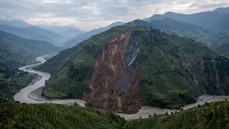
The steep, fragile slopes of the Himalayas are the second critical factor in this hazardous chain. When an earthquake strikes, the intense shaking can destabilize vast areas of rock and soil. This is particularly true for slopes that have already been fractured by past seismic activity. The tremors can cause a phenomenon known as soil liquefaction, where water-saturated soil loses its strength and behaves like a liquid, leading to catastrophic collapses. The 2015 Gorkha earthquake, for example, triggered thousands of landslides across the country, burying villages and blocking vital roadways. Even moderate shaking can be enough to dislodge loose material, turning a tremor into a fast-moving river of rock and debris.
Adding Water to the Mix
The annual monsoon season acts as a powerful accelerant in this dangerous equation. From June to September, Nepal receives about 80% of its total annual rainfall. This deluge saturates the ground, lubricating already unstable soil and rock layers that may have been weakened by earthquakes. This combination makes landslides far more likely. Studies have shown a dramatic spike in landslide activity during the monsoon season following a major earthquake, as the heavy rains provide the final push to slopes that are on the verge of collapse. Climate change is making these rainfall patterns more erratic and intense, further increasing the risk.
When Landslides Unleash Floods
The cascade doesn't end with a landslide. When massive amounts of debris slide into a river, they can form a natural dam, blocking the water's flow. Water builds up behind this unstable barrier, creating a temporary lake. These landslide-dammed lakes are incredibly dangerous. The earthen dam can fail suddenly without warning, releasing a massive and destructive torrent of water, mud, and debris downstream known as a Landslide Dam Outburst Flood (LDOF). Earthquakes and landslides can also destabilize glacial lakes, which are natural bodies of water formed by melting glaciers and held in by loose rock walls called moraines. A failure of one of these moraines can trigger a Glacial Lake Outburst Flood (GLOF), another type of catastrophic flood that can wipe out entire communities and critical infrastructure like hydropower plants.
A Compounded Crisis
This deadly sequence—from earthquake to landslide to flood—is what experts call a cascading hazard. The risk is compounded by human activity. Haphazard road construction often cuts into unstable hillsides, creating new landslide risks. Deforestation removes the tree roots that help hold soil in place, weakening slopes further. As settlements expand, more people are living in vulnerable areas along riverbanks and on steep terrain, increasing the potential for tragedy when this natural chain reaction is set in motion. Understanding this interconnection is the first step toward developing more effective early warning systems and disaster management strategies that can anticipate the next domino to fall.