





What Makes EOS-05 a Game-Changer?
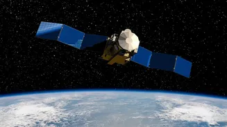
EOS-05, also known as GISAT-1A, isn't just another satellite; it's a strategic asset designed for a very specific and powerful purpose. Unlike most other Indian earth observation satellites which circle the planet in a Low Earth Orbit (LEO) of a few hundred
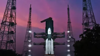
kilometres, EOS-05 operates from a much higher Geosynchronous Orbit (GEO), approximately 36,000 kilometres above the Earth. This high perch allows it to match the Earth's rotation, enabling it to 'hover' over the Indian subcontinent. The result is the ability to provide near real-time, continuous monitoring of a large area, a stark contrast to LEO satellites that can only image a specific location for a few minutes during their pass. Dubbed an "eye in the sky," it's India's first imaging satellite to be placed in such an orbit, a feat that required the powerful Geosynchronous Satellite Launch Vehicle (GSLV).
An Unblinking Eye for National Priorities
The true value of EOS-05 lies in its wide-ranging applications, serving both civilian and strategic needs. Its primary mission is to provide rapid monitoring of natural disasters. In a country frequently affected by cyclones, floods, and forest fires, the ability to get continuous imagery of an unfolding event is critical for effective disaster management and response. Beyond emergencies, the satellite will play a crucial role in agriculture by monitoring crop health and water resources, providing vital data for forestry and environmental monitoring. Furthermore, its persistent gaze over the Indian landmass and oceans provides a significant boost for national security, enabling surveillance of border areas and maritime interests. While the resolution from a geosynchronous orbit is naturally lower than that of close-range satellites like the Cartosat series, the advantage of constant coverage over a single region is a capability that ISRO has long pursued.
A Key Piece in a Larger Puzzle
EOS-05 does not operate in isolation. It joins one of the world's largest constellations of remote sensing satellites, a program India began in 1988 with the launch of IRS-1A. This new satellite complements a diverse family of existing assets. For instance, the EOS-04 (or RISAT-1A) satellite provides high-resolution, all-weather radar imaging, which is invaluable for mapping and monitoring during heavy cloud cover, such as in the monsoon season. Other satellites in the Resourcesat and Oceansat series are tailored for specific tasks related to land resources and oceanographic studies, respectively. The data from this entire network is channelled through platforms like Bhuvan, ISRO's geo-portal, which makes the information accessible for various national development and governance applications. EOS-05 fills a unique niche within this system, providing the broad, persistent overview that other satellites, with their specific orbital paths, cannot.
Redemption and a Look to the Future
The successful deployment of EOS-05 is also a story of resilience for the Indian Space Research Organisation (ISRO). An earlier attempt to place a similar satellite, EOS-03, into orbit in August 2021 ended in failure due to an issue with the launch vehicle's upper stage. The successful launch of EOS-05 aboard the GSLV-F17 not only overcomes that setback but also reinforces the reliability of the GSLV rocket for placing heavy payloads into high orbits. This mission is a stepping stone. India's space policy is increasingly integrating private industry and planning for proliferated LEO constellations for even more resilient surveillance and communication. With major upcoming missions like the joint NASA-ISRO NISAR satellite for advanced radar imaging, India's ability to monitor our planet is set to become even more sophisticated, ensuring that the 'eyes in the sky' are sharper and more watchful than ever.