






More Than Just Waterlogging
In the national consciousness, monsoon fury is synonymous with submerged arterial roads in megacities. However, for India's burgeoning tier-2 and tier-3 cities, the risks are more complex and often more insidious. Unlike their metropolitan counterparts,
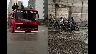
smaller cities grapple with a unique combination of rapid, unplanned expansion and legacy infrastructure that was never designed for current climate realities. The result isn't just inconvenient waterlogging; it’s a systemic breakdown. Drains that double as sewage lines and are choked with solid waste quickly become vectors for disease. Haphazard construction on former wetlands and floodplains means even moderate rainfall can lead to severe, localised floods that receive little to no media attention. These areas often lack the specialised disaster response teams found in state capitals, making them dangerously reliant on under-resourced local bodies when crisis strikes.
When Warnings Don't Warn
India's disaster management framework, including early warning systems from the India Meteorological Department (IMD), has grown more sophisticated. We now have better technology for forecasting intense rainfall. The problem lies in the last mile: communication. A generic alert for an entire district is of little use to a resident whose neighbourhood is uniquely vulnerable due to its specific topography or proximity to a choked drain. This is the critical gap that current monsoon risk explainers fail to bridge. Information is often too technical, broadcast through channels that don't reach everyone, or lacks actionable advice. An alert that warns of "heavy rainfall" without explaining what that means for a specific low-lying settlement or a poorly constructed bridge fails in its primary mission to protect lives. The communication breakdown turns a forecast into noise, leaving citizens unable to connect the warning to their immediate reality.
What a Good Explainer Looks Like
Effective risk communication is not about broadcasting more data; it's about delivering targeted, understandable, and actionable intelligence. For a small city, a good explainer would be hyperlocal. Imagine a system where instead of a district-wide alert, you receive a notification for your specific ward, complete with a map showing which roads are prone to flooding and identifying safe evacuation routes. The National Disaster Management Authority (NDMA) guidelines have long called for such ward-level information systems and clearer communication protocols. This involves translating meteorological jargon into plain language. For example, instead of saying "100mm of rain expected," an effective message would state, "Rainfall heavy enough to flood the market road and underpass is expected in the next three hours. Avoid these areas." This approach empowers people to make specific, life-saving decisions.
Building Resilience from the Ground Up
Ultimately, better explainers are not just a top-down directive from a central agency. They must be built on a foundation of local knowledge and community participation. Residents of a locality often have generations of experience with how water flows and where it pools. Integrating this local knowledge with scientific forecasts can create a far more robust and credible warning system. Urban local bodies need to be empowered—financially and technically—to move beyond pre-monsoon desilting and create these localised communication strategies. This means investing in community-based disaster management units, conducting regular drills, and establishing clear channels for two-way communication where citizens can report issues and receive tailored advice. When communities are involved in identifying their own risks, they are more likely to trust and act on the warnings they receive.