





India's Eyes in the Sky
The Indian Space Research Organisation (ISRO) is at the heart of the nation's high-tech approach to disaster management. Through its Disaster Management Support (DMS) Programme, ISRO utilizes a sophisticated constellation of satellites to keep a watchful
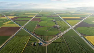
eye over the subcontinent. This fleet includes Earth observation satellites, meteorological satellites, and communication satellites, all working in concert. Key players in this orbital team include the INSAT series, which provides crucial weather and communication data, and the IRS (Indian Remote Sensing) series, which offers detailed land and resource imaging. Satellites like the RISAT (Radar Imaging Satellite) are particularly vital as they can see through clouds and darkness, making them invaluable for monitoring floods and cyclones regardless of weather conditions. These satellites provide a continuous stream of data, offering synoptic observations that are essential for planning and managing disaster response.
From Raw Data to Actionable Intelligence
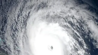
Collecting data from space is only the first step. The real magic happens when this information is processed and turned into actionable intelligence. This is the work of agencies like the National Remote Sensing Centre (NRSC) in Hyderabad. Using technologies like Geographic Information Systems (GIS), scientists can overlay satellite imagery with ground-level data, such as village boundaries, road networks, and population density. For instance, during a flood, satellite data helps identify the precise extent of inundated areas. This information is then used to create detailed maps that guide rescue teams on the ground. Similarly, for cyclones, satellites help track the storm's formation, intensity, and path, enabling the India Meteorological Department (IMD) to issue timely and accurate warnings. This process transforms complex satellite readings into clear, practical plans that save lives.
Connecting Space to the Ground
Getting the right information to the right people at the right time is critical. ISRO ensures that the processed data is disseminated swiftly to all relevant authorities, from central ministries to state-level disaster management bodies. A key platform for this is the National Database for Emergency Management (NDEM), a geo-portal developed by ISRO that provides interactive, geospatial information to administrators. This database is a core component of the Integrated Control Room for Emergency Response (ICR-ER), a centralized command centre run by the Ministry of Home Affairs. This ensures seamless coordination between national and state agencies, like the National Disaster Management Authority (NDMA) and the National Disaster Response Force (NDRF), allowing them to mobilise resources and conduct evacuation and relief operations with precision.
A Proactive Approach to Safety
Beyond real-time response, satellite data is increasingly used for proactive mitigation and long-term planning. By analyzing historical satellite imagery, authorities can identify and map areas that are prone to specific hazards like landslides, floods, or droughts. For example, ISRO has helped develop a Flood Hazard Zonation Atlas for Assam, a state highly vulnerable to flooding, which aids in better development planning and building agricultural resilience. Similarly, satellite data on vegetation health and soil moisture helps in monitoring drought conditions, allowing for early intervention. This shift from a purely relief-based approach to a proactive, technology-driven strategy is fundamental to building a disaster-resilient India. India's expertise is also recognised globally, with ISRO playing a lead role in international collaborations like the International Charter 'Space & Major Disasters'.