






What Exactly Is El Niño?
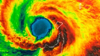
At its core, El Niño is a naturally occurring climate phenomenon characterised by the unusual warming of sea surface temperatures in the central and eastern equatorial Pacific Ocean. This is the warm phase of a larger cycle called the El Niño-Southern
Oscillation (ENSO). Think of it as a massive redistribution of heat in the world's largest ocean, an event that happens every two to seven years. This warming might seem distant, but it sets off a chain reaction in the atmosphere that can disrupt weather patterns globally, including a significant influence on the Indian southwest monsoon.
The Pacific-to-India Connection
The key to understanding El Niño's impact on India lies in a vast atmospheric circulation pattern known as the Walker Circulation. Normally, high pressure over the eastern Pacific and low pressure over the warmer western Pacific (near Indonesia) drive strong easterly trade winds. These winds help pull moisture-laden air towards the Indian subcontinent, feeding the monsoon. During an El Niño, this pattern weakens or even reverses. The warm water shifts eastward in the Pacific, causing the area of low pressure to move with it. This disruption slows down the atmospheric engine that powers the monsoon, reducing the flow of moisture and suppressing rainfall over India.
Typical Monsoon Impact
Historically, El Niño years are strongly correlated with below-normal rainfall and drought conditions in India. With around 70-75% of the country's annual rainfall arriving during the southwest monsoon, any disruption has serious consequences. A weaker monsoon often leads to reduced agricultural output, particularly for rain-fed kharif crops like rice, pulses, and oilseeds. This not only impacts food security and pushes up inflation but also affects the incomes of millions of farmers, which in turn can slow down the broader rural economy, affecting sales of everything from tractors to consumer goods.
The Indian Ocean's Counter-Move
However, an El Niño does not automatically guarantee a drought in India. Another climate pattern, the Indian Ocean Dipole (IOD), can play a crucial mitigating role. The IOD is the Indian Ocean's own version of El Niño, involving a temperature difference between the western and eastern parts of the ocean. During a 'positive' IOD, the western Indian Ocean becomes warmer than the east. This condition can actually help the monsoon by bringing more moisture towards the Indian subcontinent, sometimes counteracting the drying effect of an El Niño. The interplay between these two phenomena is why some El Niño years still produce normal monsoon rainfall.
A Paradox of Extremes
Recent research has uncovered a surprising twist in the El Niño story. While it tends to reduce the total amount of rainfall over the season, it can simultaneously increase the frequency of extreme rainfall days in certain regions. Studies have shown that during El Niño summers, central India and the Western Ghats may experience fewer rainy days overall, but the downpours that do occur can be more intense and destructive. In contrast, traditionally drier regions in the southeast and northwest tend to see rainfall suppressed across the board. This highlights that the impact is not uniform, creating a complex picture of both drought and flood risk within the same season.