





A Sharper Eye Through the Clouds
At the heart of this advancement is Synthetic Aperture Radar (SAR), a powerful technology that sets ISRO's satellites apart. Unlike traditional optical satellites that are blinded by clouds and darkness, SAR can peer through the thickest monsoon cloud cover,
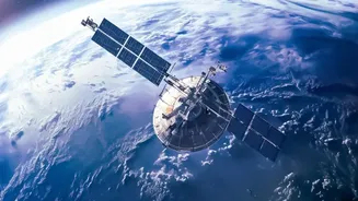
day or night. This all-weather capability is crucial for monitoring the turbulent conditions that spawn cyclones and subsequent storm surges. India's RISAT (Radar Imaging Satellite) series, developed by ISRO, provides this critical surveillance. These satellites send microwave pulses to the Earth's surface and interpret the returning signals to create detailed images. This technology enables them to detect subtle changes on the surface with high resolution, which is vital for disaster monitoring. The ongoing advancements in this satellite fleet represent a significant upgrade in the nation's ability to see a storm developing in its entirety, without the interruptions posed by weather.
The Unique Danger of Storm Surges
A storm surge is not a tsunami or a simple high tide; it is an abnormal rise of water generated by a storm, over and above the predicted astronomical tides. When a powerful cyclone approaches the coast, the strong winds and low pressure at its center essentially push and pull the ocean water into a massive dome. This wall of water then crashes ashore, causing catastrophic flooding far inland. Predicting the exact height and location of a storm surge is incredibly complex, as it depends on the cyclone's intensity, speed, size, and the angle at which it makes landfall. For India, with its 7,500-kilometer coastline and densely populated low-lying areas, accurate and timely warnings are a matter of life and death. The ability to precisely map coastal topography and monitor the sea-state in real-time is where advanced radar imaging becomes indispensable.
From Raw Data to Life-Saving Alerts
Capturing images from space is only the first step. The real magic happens when this data is processed and turned into actionable intelligence for disaster management agencies on the ground. ISRO has established a robust Disaster Management Support Programme (DMSP) to ensure its space-based inputs are effectively used. Data from satellites like the RISAT and INSAT series are relayed to centres like the National Remote Sensing Centre (NRSC) in Hyderabad. Here, experts analyse the information to create near real-time maps of potential inundation and assess risks. This vital information is then disseminated to the National Disaster Management Authority (NDMA) and respective State Disaster Management Authorities. This seamless coordination allows authorities to issue targeted evacuation orders, mobilize resources to vulnerable areas, and ultimately, save lives. The Flood Early Warning System (FLEWS), developed by an ISRO centre, is one such model already in use to forecast flood events.
The Future: A Joint Leap Forward with NISAR
The next major advancement is already on the horizon. The NASA-ISRO Synthetic Aperture Radar (NISAR) mission, a joint collaboration, promises to be the world's most expensive and advanced Earth-observation satellite. Scheduled for a near-future launch, NISAR will carry both L-band and S-band radar systems, a first for any satellite. It will scan nearly the entire planet every 12 days, detecting surface changes as small as a centimeter. While its applications are vast—from tracking glacier melt to monitoring agricultural land—its role in disaster management will be transformative. For storm surges, NISAR will be able to monitor the health of natural buffers like mangroves, identify erosion-prone coastal areas, and support flood extent mapping with unprecedented detail, even in near-real time. This constant and precise monitoring will give authorities a powerful predictive tool to better prepare for and mitigate the impact of coastal hazards.