








A New Generation of Eyes in the Sky
At the heart of India's storm-tracking efforts are its advanced Earth observation satellites. Series like INSAT and Oceansat provide a constant stream of data, forming the backbone of the country's weather forecasting and disaster management programs.
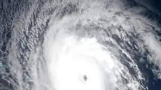
Recently, satellites such as INSAT-3DR, INSAT-3DS, and Oceansat-3 (also known as EOS-06) have become crucial for monitoring the entire lifecycle of a cyclone. These platforms are specifically designed for meteorological and oceanographic studies, helping to observe everything from sea surface temperatures to cloud formations. This constant surveillance is critical for a nation with a vast coastline vulnerable to the annual monsoon.
What the 'Upgrades' Really Mean
The upgrades aren't just about launching new hardware; they involve a suite of technological enhancements. Key among these are advanced sensors like scatterometers, which are vital for predicting the formation of cyclones. A scatterometer is a type of radar that measures wind speed and direction over the ocean, allowing meteorologists to spot the tell-tale signs of a developing storm system, or cyclogenesis, often four to five days in advance. For example, the scatterometer on the EOS-06 satellite provides crucial data on ocean wind patterns and circulation before a cyclone even forms. This is complemented by multispectral imagers on satellites like INSAT-3DR, which can analyse a storm's structure in real-time, giving clues about its intensity.
From Satellite Data to Public Warning
Raw data from space is just the first step. This information is beamed down to ground stations, where agencies like the India Meteorological Department (IMD) process it. By integrating satellite observations into advanced numerical weather prediction models, forecasters can significantly improve their accuracy. ISRO's geoportals, such as Bhuvan and MOSDAC (Meteorological and Oceanographic Satellite Data Archival Centre), play a vital role in disseminating this information to various disaster management authorities. This collaborative effort ensures that a satellite image of a vortex over the Arabian Sea is quickly translated into an actionable warning for officials and the public in Gujarat.
The Real-World Impact: Saving Lives
The ultimate goal of these technological advancements is to save lives and minimise damage. More accurate and timely warnings translate into tangible benefits. Longer lead times—predicting a cyclone's formation days in advance—give authorities crucial time to prepare and carry out evacuations. Improved track and intensity forecasts mean resources can be deployed more effectively, avoiding unnecessary panic in areas not at risk while ensuring those in the direct path are alerted. Satellites like Oceansat-2 proved their worth during past cyclones like Phailin, where accurate data was critical for the disaster response. The current generation of satellites builds on that legacy, providing an even clearer picture of impending threats.
AI and the Future of Coastal Safety
Looking ahead, ISRO is integrating Artificial Intelligence (AI) to make its warning systems even smarter. In one recent initiative, AI is being used to analyse satellite imagery and other data to detect dangerous rip currents along beaches in real-time, a major cause of drowning accidents. This ability to transform environmental data into instant, actionable insights points to the future of disaster management. As ISRO continues to develop its next series of satellites, such as the planned INSAT-4 series with even better sensors and resolution, the goal remains the same: to leverage India's space capabilities for the direct safety and prosperity of its people on the ground.