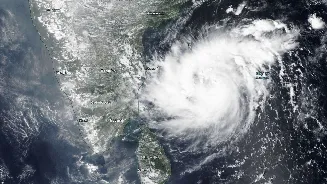








The Current Status: Cyclone Akvan Is Here
The India Meteorological Department (IMD) has confirmed the formation of Cyclonic Storm 'Akvan'. The system originated from a low-pressure area that formed over the southeast Bay of Bengal around November 13 and subsequently intensified. It was officially
named Akvan on the evening of November 16 after strengthening from a deep depression into a cyclonic storm. As of the morning of November 18, the system has intensified into a Severe Cyclonic Storm over the west-central Bay of Bengal. The IMD is tracking its movement closely, providing regular updates on its position and strength.
IMD's Forecast: Path and Intensity
According to the latest IMD bulletins, Cyclone Akvan is moving in a north-northwestward direction. Forecasters predict it will continue to intensify, likely becoming a Very Severe Cyclonic Storm by the evening of November 19. The current forecast track indicates that Akvan is expected to make landfall along the Andhra Pradesh coast, somewhere between Nellore and Visakhapatnam, around noon on November 20. At the time of landfall, the storm is predicted to have maximum sustained wind speeds of 120-130 kmph, with gusts reaching up to 145 kmph. Authorities in coastal Andhra Pradesh and adjoining areas of Odisha have been placed on high alert.
The Third Cyclone: A Busy Post-Monsoon Season
Cyclone Akvan is indeed the third named cyclonic storm in the North Indian Ocean this year, following Cyclone Arnab in October and Cyclone Murasu in early November. Both previous storms also impacted India's eastern coast. This active post-monsoon season aligns with some seasonal predictions. The period from October to December is one of the two main peaks for cyclone formation in the North Indian Ocean, often producing more intense storms than the pre-monsoon season (April to June). The warm waters of the Bay of Bengal provide the necessary energy for these weather systems to develop and strengthen.
How Cyclones Get Their Names
The name 'Akvan' was contributed by Iran and was next on the predetermined list for cyclones in this region. The naming process is a coordinated effort among 13 member countries of the WMO/ESCAP Panel on Tropical Cyclones. This panel includes India, Bangladesh, Iran, Pakistan, and others. A storm is assigned a name by the Regional Specialised Meteorological Centre (RSMC) in New Delhi—run by the IMD—only when it reaches the intensity of a Cyclonic Storm, with wind speeds of at least 62 kmph. Using short, distinct names helps in clear communication and avoids confusion, especially when multiple weather systems are active.
Understanding IMD Alerts and Staying Safe
The IMD uses a clear classification system based on wind speed, ranging from a 'Depression' to a 'Super Cyclonic Storm'. As Akvan intensifies, alerts for affected coastal districts will escalate. The IMD has already issued warnings for heavy to extremely heavy rainfall for coastal Andhra Pradesh and parts of Odisha, with rainfall also expected in Tamil Nadu, Telangana, and West Bengal. Fishermen have been strongly advised to return to the coast and avoid venturing into the Bay of Bengal. For the public, it is essential to follow official updates from the IMD and local disaster management authorities, prepare for potential power outages, and avoid spreading unverified information from social media.