





The El Niño Effect Takes Hold
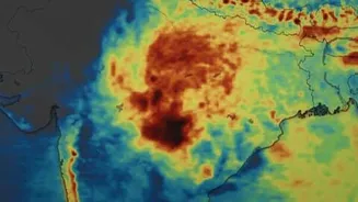
The most significant global factor influencing India's monsoon this year is the strengthening El Niño phenomenon in the Pacific Ocean. El Niño is characterized by unusually warm surface waters in the equatorial Pacific, which can disrupt weather patterns
worldwide. For India, it typically means suppressed rainfall. Meteorologists have noted that the impact of El Niño is becoming more pronounced in the second half of the monsoon season. This large-scale pattern creates atmospheric conditions that are less favourable for the development of strong, moisture-laden monsoon systems that travel towards India's west coast, leading to prolonged dry spells or weaker rainfall. Forecasters had warned that El Niño would likely intensify from August onwards, and its effects are now being clearly felt across the subcontinent.
An Unhelpful Madden-Julian Oscillation
Think of the Madden-Julian Oscillation (MJO) as a massive, eastward-moving pulse of clouds and rainfall that travels around the tropics over 30 to 60 days. When the MJO's active phase is over the Indian Ocean, it significantly enhances monsoon activity. However, in late August 2026, the MJO has been lingering in an unfavourable phase for India. Its active rainfall zone is positioned over the Western Pacific, which does the opposite for India: it suppresses convection and rainfall over the subcontinent. Weather experts point to this unfavourable MJO phase as a primary reason for the reduced rainfall activity, noting that even when local conditions seem ripe, this large-scale suppression makes it difficult for sustained heavy showers to organize.
The Missing Low-Pressure Systems
Mumbai's heaviest rainfall spells are often driven by strong weather systems, particularly low-pressure areas or depressions that form in the Bay of Bengal and move west across Central India. These systems act like engines, pulling moisture from the Arabian Sea and dumping it over the Konkan coast, including Mumbai. In recent weeks, there has been a notable absence of such powerful systems making their way across the country to influence the west coast. While some systems have formed, they have been concentrated over eastern and central India, failing to create the strong westerly winds needed to bring sustained, heavy rain to Mumbai. This lack of a strong 'pull' from inland weather systems has left the Arabian Sea branch of the monsoon in a relatively weaker state.
A Weaker Somali Jet Stream
The Somali Jet is a crucial component of the monsoon engine. It's a powerful, low-level cross-equatorial jet of air that transports massive amounts of moisture from the southern Indian Ocean towards the Indian subcontinent. A strong Somali Jet is vital for a vigorous monsoon onset and sustained rainfall along the west coast. Earlier in the season, meteorologists had already identified a weakened Somali Jet as a reason for the monsoon's sluggish advance. During a 'break' or weak monsoon phase, this jet stream often slackens. Its reduced intensity means less moisture is forcefully pushed towards the coast, contributing directly to the kind of lull Mumbai is currently experiencing, with lighter rain and more humid, breezy conditions instead of torrential downpours.
The Struggling Indian Ocean Dipole
Another important factor is the Indian Ocean Dipole (IOD), sometimes called the Indian Niño. A 'positive' IOD, with warmer sea surface temperatures in the western Indian Ocean (the Arabian Sea), can help counteract the negative effects of El Niño and boost the monsoon. However, throughout much of the 2026 season, the IOD has remained neutral and has struggled to establish itself in a positive phase. While some models suggest a positive IOD might still develop late in the season, its failure to do so decisively has meant that a key counter-balance to the suppressive effects of El Niño has been missing in action, leaving the monsoon more vulnerable to the larger Pacific pattern.