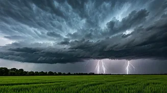


What's Happening Now: The Current Weather Scenario
North India is currently under the influence of pre-monsoon activity, intensified by an active western disturbance. [11] The India Meteorological Department (IMD) has issued alerts for thunderstorms accompanied by lightning and gusty winds, with speeds
potentially reaching 50-60 kmph in some areas. [6, 19] These conditions are a precursor to the Southwest Monsoon, which is advancing across the country and is expected to reach North India, including Delhi, around its normal onset date of June 27. [7] While this change provides much-needed relief from the prolonged heatwave, the transition period is marked by severe weather events. [5, 21] For June 25, the IMD has forecast moderate to heavy rainfall in Delhi, accompanied by strong winds. [16]
Which Regions Are on Alert?
The alerts cover a wide swath of North India. The IMD has issued warnings for thunderstorms and strong winds for states including Delhi-NCR, Haryana, Punjab, Rajasthan, and Uttar Pradesh. [6] A yellow alert for moderate to heavy rain has been issued for several districts in Uttar Pradesh, including Bulandshahr, Mathura, Agra, and Varanasi. [16] Similar alerts are in place for parts of Haryana and Punjab. [19, 21] The Himalayan states of Uttarakhand and Himachal Pradesh are also on alert for rainfall and thunderstorms, particularly from June 29 onwards. [18] Residents in all these regions are advised to stay updated with local forecasts as conditions can change rapidly. [26]
Understanding IMD's Colour-Coded Warnings
To communicate the severity of weather, the IMD uses a colour-coded system. A 'Yellow' alert, which is currently active in many parts of Delhi-NCR and UP, advises residents to 'Be Aware'. [5, 16] It indicates the potential for weather that could cause localized disruptions. An 'Orange' alert signals to 'Be Prepared' for potentially bad weather that could disrupt travel and power. A 'Red' alert is the highest level, warning of a high likelihood of severe weather and advising authorities and the public to 'Take Action' to protect life and property. [17] Understanding these warnings helps in gauging the seriousness of the situation and taking appropriate measures.
How to Stay Safe: Essential Precautions
Safety is paramount during thunderstorms. The IMD and disaster management agencies advise a clear set of 'Dos and Don'ts'. If you hear thunder, go indoors immediately. [10] The safest shelters are concrete buildings or hard-top vehicles with the windows rolled up. [14, 15] Avoid taking shelter under isolated trees, as they attract lightning. [10] Inside, unplug electrical appliances and avoid using corded phones or taking showers, as lightning can travel through plumbing and wiring. [9, 15] Secure any loose objects outside your home, like garden furniture or bins, that could be blown away by strong winds. [12] If caught outdoors with no shelter, crouch down in a low-lying area, making yourself as small a target as possible. [14] Postpone travel if possible, as heavy rain can cause waterlogging and reduce visibility, leading to traffic disruptions. [5, 12]
Official Resources and Staying Informed
For the most accurate and up-to-date information, rely on official sources. The IMD regularly updates its website (mausam.imd.gov.in) with the latest forecasts, warnings, and radar imagery. [20, 27] Many state disaster management authorities also disseminate alerts through SMS and social media. Local news channels and radio are also reliable sources for real-time updates. [12] Following these official channels ensures you receive timely and accurate information, helping you make informed decisions to ensure your safety and the safety of those around you. Being prepared and staying informed is the best defence against severe weather. [26]