






An Unblinking Eye Called NISAR
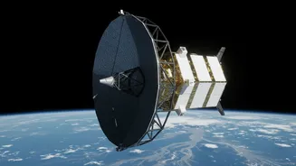
The source of this powerful new data is the NISAR (NASA-ISRO Synthetic Aperture Radar) satellite, a joint Earth-observing mission that represents a new high in space collaboration between the United States and India. Launched in mid-2025, NISAR is now
in its science operations phase, systematically scanning our planet. What makes it a game-changer is its advanced radar technology. Unlike optical satellites that are essentially cameras in space, NISAR uses radar to observe Earth's surface. Its data is now being actively processed and released by ISRO, with recent images capturing the dynamic Brahmaputra River during Assam's flood season. The mission is designed to map nearly the entire globe every 12 days, providing an incredibly detailed and consistent stream of information about changes on the ground.
The Superpower of Seeing Through Clouds
For a country like India, where monsoon clouds blanket the sky for months, traditional satellites are often blinded during the most critical periods of flooding. This is where NISAR’s primary advantage lies. Its dual-frequency radar (L-band and S-band) can penetrate cloud cover, smoke, and darkness, allowing it to monitor the situation on the ground, day or night, in any weather. This all-weather capability is crucial for tracking the real-time evolution of a flood. The L-band radar, provided by NASA, can even see through vegetation canopies to detect waterlogged land or inundated forests, something that has been extremely difficult until now. This provides a much clearer picture of the true extent of flooding, even in densely forested regions like the Western Ghats or the Sunderbans.
How Data Becomes a Flood Warning
So, how does a satellite image translate into a life-saving warning? NISAR provides several critical data points for flood models. It can precisely measure changes in water levels in rivers and floodplains, acting like a network of 'virtual stream gauges' across the country. By comparing images taken just days apart, scientists can detect subtle surface changes—down to a centimeter—that indicate rising water levels or saturated soil, both precursors to floods. This information allows authorities to predict not just if a flood will happen, but how severe it might be and which areas are most at risk. With data products expected to be available within hours of observation in disaster scenarios, response teams can get timely, actionable intelligence to plan evacuations and deploy resources more effectively.
A Landmark Partnership for a Safer Future
The NISAR mission is more than just a technological marvel; it's a testament to the strengthening strategic partnership between India and the United States. As one of the most expensive Earth-imaging satellites ever built, with a cost of around $1.5 billion, it represents a significant joint investment in science and public safety. NASA provided the L-band radar and other key components, while ISRO contributed the satellite structure, the S-band radar, and the GSLV launch vehicle. All data from the mission is being made freely and openly available, benefiting not just India but the entire global community in its efforts to manage natural disasters.
Beyond Floods: A Tool for a Changing Planet
While its potential for flood forecasting is a headline achievement, NISAR’s capabilities extend far beyond. The same data can be used to monitor the health of crops and forests, track the slow movement of land that might signal a landslide, measure the melting of Himalayan glaciers, and understand the dynamics of earthquakes. By providing a comprehensive, high-resolution look at Earth's complex systems, NISAR will contribute to a wide range of scientific fields and applications, from improving agricultural productivity to bolstering infrastructure resilience. This makes it a multipurpose tool that will help India monitor its environmental and geological health for years to come.